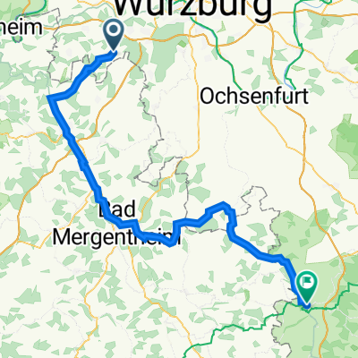
MTB-Rundreise rund um Waldbrunn
A cycling route starting in Waldbrunn, Bavaria, Germany.
Overview
About this route
Rundreise Waldbrunn - Steinbachtal - Zell - Erlabrunn - Zellingen -Leinach - Remlingen - Üttingen - Rossbrunn - Waldbrunn
sehr schön mit Einkehrmöglichkeit beim Italiener in Zellingen am Main
- -:--
- Duration
- 61.8 km
- Distance
- 372 m
- Ascent
- 372 m
- Descent
- ---
- Avg. speed
- ---
- Avg. speed
Route quality
Waytypes & surfaces along the route
Waytypes
Track
20.7 km
(34 %)
Quiet road
16 km
(26 %)
Surfaces
Paved
50.6 km
(82 %)
Unpaved
5.9 km
(10 %)
Asphalt
46.7 km
(76 %)
Paved (undefined)
2.2 km
(4 %)
Continue with Bikemap
Use, edit, or download this cycling route
You would like to ride MTB-Rundreise rund um Waldbrunn or customize it for your own trip? Here is what you can do with this Bikemap route:
Free features
- Save this route as favorite or in collections
- Copy & plan your own version of this route
- Sync your route with Garmin or Wahoo
Premium features
Free trial for 3 days, or one-time payment. More about Bikemap Premium.
- Navigate this route on iOS & Android
- Export a GPX / KML file of this route
- Create your custom printout (try it for free)
- Download this route for offline navigation
Discover more Premium features.
Get Bikemap PremiumFrom our community
Other popular routes starting in Waldbrunn
- Karfreitag Tour
- Distance
- 38.7 km
- Ascent
- 510 m
- Descent
- 449 m
- Location
- Waldbrunn, Bavaria, Germany
- Abkürzung Waldi- Ri. Volkach-Würzb.-Waldbrunn
- Distance
- 61.2 km
- Ascent
- 453 m
- Descent
- 454 m
- Location
- Waldbrunn, Bavaria, Germany
- Kante Bergtheim
- Distance
- 85.1 km
- Ascent
- 492 m
- Descent
- 495 m
- Location
- Waldbrunn, Bavaria, Germany
- eisingen Aschaffenburg
- Distance
- 108.4 km
- Ascent
- 679 m
- Descent
- 835 m
- Location
- Waldbrunn, Bavaria, Germany
- Waldbrunn- Badesee Grafenreinfeld
- Distance
- 52.9 km
- Ascent
- 267 m
- Descent
- 308 m
- Location
- Waldbrunn, Bavaria, Germany
- Kolpingstraße 14, Waldbrunn nach St2310, Holzkirchen
- Distance
- 13.9 km
- Ascent
- 55 m
- Descent
- 174 m
- Location
- Waldbrunn, Bavaria, Germany
- 300er Gegend
- Distance
- 297 km
- Ascent
- 443 m
- Descent
- 444 m
- Location
- Waldbrunn, Bavaria, Germany
- Tour de France Etappe 2:
- Distance
- 200 km
- Ascent
- 1,148 m
- Descent
- 1,277 m
- Location
- Waldbrunn, Bavaria, Germany
Open it in the app