

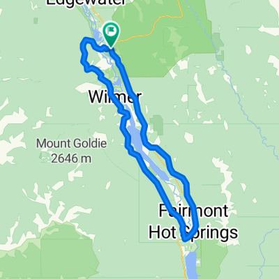
Radium Hot Springs - Vermillion Crossing
A cycling route starting in Invermere, British Columbia, Canada.
Overview
About this route
Diese Etappe hat es in sich, von Radium geht es zunächst stetig bergauf (8% Steigung) zum Sinclair Pass und dann hinein in den urwüchsigen und weitgehend unberührten Kootenay NP.
Die einzige Verpflegungs- und Übernachtungsmöglichkeit auf dem Weg von Radium ins Bow Valley bietet die Lodge in Vermillion Crossing
- -:--
- Duration
- 67.1 km
- Distance
- 847 m
- Ascent
- 591 m
- Descent
- ---
- Avg. speed
- ---
- Max. altitude

Route quality
Waytypes & surfaces along the route
Waytypes
Access road
9.4 km
(14 %)
Quiet road
2 km
(3 %)
Undefined
55.7 km
(83 %)
Surfaces
Paved
15.4 km
(23 %)
Concrete
15.4 km
(23 %)
Undefined
51.7 km
(77 %)
Continue with Bikemap
Use, edit, or download this cycling route
You would like to ride Radium Hot Springs - Vermillion Crossing or customize it for your own trip? Here is what you can do with this Bikemap route:
Free features
- Save this route as favorite or in collections
- Copy & plan your own version of this route
- Sync your route with Garmin or Wahoo
Premium features
Free trial for 3 days, or one-time payment. More about Bikemap Premium.
- Navigate this route on iOS & Android
- Export a GPX / KML file of this route
- Create your custom printout (try it for free)
- Download this route for offline navigation
Discover more Premium features.
Get Bikemap PremiumFrom our community
Other popular routes starting in Invermere
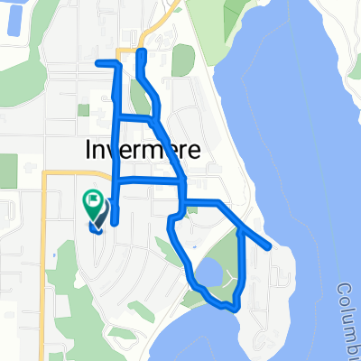
 Invermere/lake Columbia
- Distance
- 104 km
- Ascent
- 606 m
- Descent
- 607 m
- Location
- Invermere, British Columbia, Canada
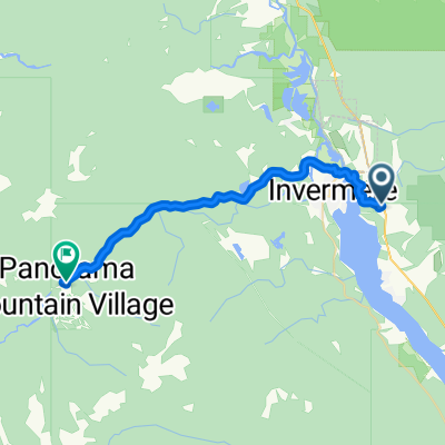 4979 Timbervale Pl, Invermere to 2000 Panorama Dr, Panorama
- Distance
- 24.1 km
- Ascent
- 443 m
- Descent
- 162 m
- Location
- Invermere, British Columbia, Canada
 1267–1399 Westside Rd, East Kootenay to 1815–1905 Westside Rd, East Kootenay
- Distance
- 29 km
- Ascent
- 677 m
- Descent
- 657 m
- Location
- Invermere, British Columbia, Canada
 Route to 1715–1723 Westside Rd, Invermere
- Distance
- 11.3 km
- Ascent
- 296 m
- Descent
- 291 m
- Location
- Invermere, British Columbia, Canada
 10A Ave, Invermere to 11th Ave, Invermere
- Distance
- 7.2 km
- Ascent
- 122 m
- Descent
- 118 m
- Location
- Invermere, British Columbia, Canada
 1023–1147 Windermere Loop Rd, East Kootenay to 1018 Swansea Rd, East Kootenay
- Distance
- 13.7 km
- Ascent
- 174 m
- Descent
- 176 m
- Location
- Invermere, British Columbia, Canada
 Invermere - Old Couch Road & Lower
- Distance
- 16.6 km
- Ascent
- 208 m
- Descent
- 208 m
- Location
- Invermere, British Columbia, Canada
 X - Radium 100 KM
- Distance
- 97.3 km
- Ascent
- 691 m
- Descent
- 672 m
- Location
- Invermere, British Columbia, Canada
Open it in the app