

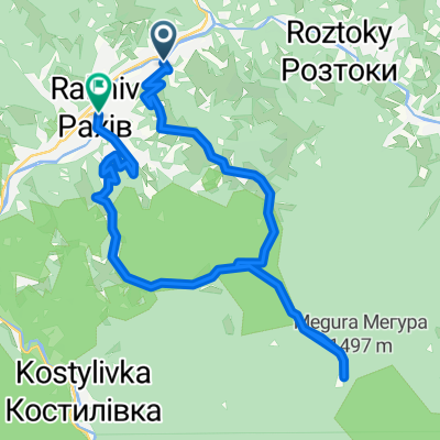
Білин-Говерла
A cycling route starting in Lazi, Zakarpattia Oblast, Ukraine.
Overview
About this route
- -:--
- Duration
- 46.2 km
- Distance
- 1,660 m
- Ascent
- 118 m
- Descent
- ---
- Avg. speed
- ---
- Max. altitude
Route quality
Waytypes & surfaces along the route
Waytypes
Track
19.8 km
(43 %)
Road
15.8 km
(34 %)
Surfaces
Paved
20.2 km
(44 %)
Unpaved
22.2 km
(48 %)
Asphalt
20.2 km
(44 %)
Gravel
15.8 km
(34 %)
Route highlights
Points of interest along the route
Point of interest after 30.1 km
КП
Continue with Bikemap
Use, edit, or download this cycling route
You would like to ride Білин-Говерла or customize it for your own trip? Here is what you can do with this Bikemap route:
Free features
- Save this route as favorite or in collections
- Copy & plan your own version of this route
- Sync your route with Garmin or Wahoo
Premium features
Free trial for 3 days, or one-time payment. More about Bikemap Premium.
- Navigate this route on iOS & Android
- Export a GPX / KML file of this route
- Create your custom printout (try it for free)
- Download this route for offline navigation
Discover more Premium features.
Get Bikemap PremiumFrom our community
Other popular routes starting in Lazi
 Файна стежка
- Distance
- 27.4 km
- Ascent
- 1,126 m
- Descent
- 1,142 m
- Location
- Lazi, Zakarpattia Oblast, Ukraine
 turcja dzien 5
- Distance
- 103.4 km
- Ascent
- 718 m
- Descent
- 661 m
- Location
- Lazi, Zakarpattia Oblast, Ukraine
 Устеріки-Петрос-Говерла-Пожежевська
- Distance
- 54.7 km
- Ascent
- 2,256 m
- Descent
- 1,322 m
- Location
- Lazi, Zakarpattia Oblast, Ukraine
 Білин-Піп Іван
- Distance
- 42.2 km
- Ascent
- 1,797 m
- Descent
- 291 m
- Location
- Lazi, Zakarpattia Oblast, Ukraine
 Білин-Говерла
- Distance
- 46.2 km
- Ascent
- 1,660 m
- Descent
- 118 m
- Location
- Lazi, Zakarpattia Oblast, Ukraine
 От вулиця Богдана Хмельницького 92, Рахів до вулиця Миру 140, Ясіня
- Distance
- 28.8 km
- Ascent
- 538 m
- Descent
- 341 m
- Location
- Lazi, Zakarpattia Oblast, Ukraine
 T-07-21 to Вulicya bez nazvi, Vydrychka
- Distance
- 10.7 km
- Ascent
- 72 m
- Descent
- 78 m
- Location
- Lazi, Zakarpattia Oblast, Ukraine
 От вулиця Богдана Хмельницького 91, Рахів до Украина, Яблуниця
- Distance
- 39.3 km
- Ascent
- 1,882 m
- Descent
- 1,417 m
- Location
- Lazi, Zakarpattia Oblast, Ukraine
Open it in the app