

Die Lange
A cycling route starting in Harsleben, Saxony-Anhalt, Germany.
Overview
About this route
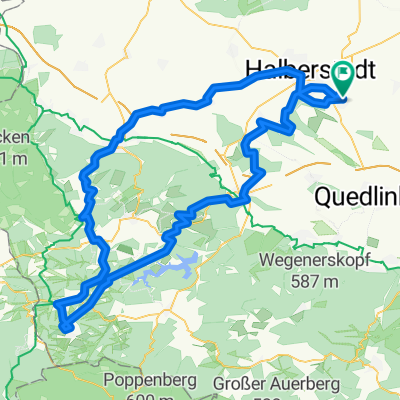
Mal eine andere Route. It will be experienced for the first time 'The Long' between Rübeland and Benneckenstein. From the start, we go over Langenstein and the Brockenstedt Mill to Blankenburg. The Herzogsweg climbs until we go over the Rübelandbahn and then towards Hüttenrode. From there over Kuhteich, then turn left towards the Blue Lake to Neuwerk. After that, left over the bridge and immediately right to the road between Rübeland and kilometer 9. The road climbs about 2km, and we turn right onto 'The Long'. Now it only goes on this road to Benneckenstein. Before the train station, turn right past the new buildings onto the woodland path to Sorge. From there, the tour continues over Tanne to Königshütte, more or less along the old railway embankment (bicycle path). At the village exit towards Elend, turn right into the Steinbach valley towards Drei Annen Hohne. A piece of Zillierbach bike path down and then left towards Hüttenstieg (Drängetal). The road about 100m down right onto the Drängetal slope path. Finally, we arrive in Hasserode, ride through Wernigerode on the Holtemme bike path to Halberstadt and to the destination.
- -:--
- Duration
- 111.7 km
- Distance
- 728 m
- Ascent
- 727 m
- Descent
- ---
- Avg. speed
- ---
- Max. altitude

Route quality
Waytypes & surfaces along the route
Waytypes
Track
52.5 km
(47 %)
Path
20.1 km
(18 %)
Surfaces
Paved
30.2 km
(27 %)
Unpaved
61.4 km
(55 %)
Gravel
29 km
(26 %)
Asphalt
26.8 km
(24 %)
Route highlights
Points of interest along the route
Point of interest after 38 km
Hier beginnt bzw. endet "Die Lange"
Point of interest after 51.5 km
Hier endet bzw. beginnt "Die Lange"
Continue with Bikemap
Use, edit, or download this cycling route
You would like to ride Die Lange or customize it for your own trip? Here is what you can do with this Bikemap route:
Free features
- Save this route as favorite or in collections
- Copy & plan your own version of this route
- Split it into stages to create a multi-day tour
- Sync your route with Garmin or Wahoo
Premium features
Free trial for 3 days, or one-time payment. More about Bikemap Premium.
- Navigate this route on iOS & Android
- Export a GPX / KML file of this route
- Create your custom printout (try it for free)
- Download this route for offline navigation
Discover more Premium features.
Get Bikemap PremiumFrom our community
Other popular routes starting in Harsleben
 Oberharz-Tour
- Distance
- 183.7 km
- Ascent
- 990 m
- Descent
- 990 m
- Location
- Harsleben, Saxony-Anhalt, Germany
 Die Lange
- Distance
- 111.7 km
- Ascent
- 728 m
- Descent
- 727 m
- Location
- Harsleben, Saxony-Anhalt, Germany
 Foto-Tour Vorharz
- Distance
- 61.1 km
- Ascent
- 365 m
- Descent
- 366 m
- Location
- Harsleben, Saxony-Anhalt, Germany
 Harsleben Ditfurt Quedlinburg Langenstein
- Distance
- 42.8 km
- Ascent
- 129 m
- Descent
- 87 m
- Location
- Harsleben, Saxony-Anhalt, Germany
 Brocken und Huy
- Distance
- 150.7 km
- Ascent
- 1,103 m
- Descent
- 1,100 m
- Location
- Harsleben, Saxony-Anhalt, Germany
 Ostharz von Selke bis Bode
- Distance
- 116.6 km
- Ascent
- 913 m
- Descent
- 911 m
- Location
- Harsleben, Saxony-Anhalt, Germany
 Hängebrücke auf Umwegen
- Distance
- 133.2 km
- Ascent
- 858 m
- Descent
- 858 m
- Location
- Harsleben, Saxony-Anhalt, Germany
 Transall - Ballenstedt
- Distance
- 98.1 km
- Ascent
- 577 m
- Descent
- 577 m
- Location
- Harsleben, Saxony-Anhalt, Germany
Open it in the app