

Phuping Palace
A cycling route starting in Chiang Mai, Chiang Mai, Thailand.
Overview
About this route
Von Ortskern Chiang Mai nimmt der Verkehr stetig ab Richtung Zoo. Ab Zoo beginnt die Steigung ununterbrochen bin zum Tempel Wat Phrathat Doi Suthep im Schnitt mit 6%
Der Tempel ist eine Pilgerstätte für Thais. Hier säumen sich die Strassenverkäufer auf einige 100m.
Hinter dem Tempel geht es weiter bergan, die Strasse wird zunehmends schmaler und auch die Steigung nimmt zu. Das Ziel is am Kreisverkehr.
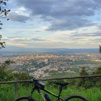
Wenn das Wetter gut ist, hat man während der Fahrt einige schöne Aussichten, bei schlechtem Wetter hängt man in der Wolke, dafür ist die Temperatur angenehm,
- -:--
- Duration
- 52.2 km
- Distance
- 1,083 m
- Ascent
- 1,098 m
- Descent
- ---
- Avg. speed
- ---
- Max. altitude

Route quality
Waytypes & surfaces along the route
Waytypes
Quiet road
10.4 km
(20 %)
Access road
2.1 km
(4 %)
Surfaces
Paved
51.2 km
(98 %)
Asphalt
46.5 km
(89 %)
Concrete
4.7 km
(9 %)
Undefined
1 km
(2 %)
Continue with Bikemap
Use, edit, or download this cycling route
You would like to ride Phuping Palace or customize it for your own trip? Here is what you can do with this Bikemap route:
Free features
- Save this route as favorite or in collections
- Copy & plan your own version of this route
- Sync your route with Garmin or Wahoo
Premium features
Free trial for 3 days, or one-time payment. More about Bikemap Premium.
- Navigate this route on iOS & Android
- Export a GPX / KML file of this route
- Create your custom printout (try it for free)
- Download this route for offline navigation
Discover more Premium features.
Get Bikemap PremiumFrom our community
Other popular routes starting in Chiang Mai
 MHS Loop
- Distance
- 533.7 km
- Ascent
- 5,294 m
- Descent
- 5,289 m
- Location
- Chiang Mai, Chiang Mai, Thailand
 DoiSuthep
- Distance
- 49.9 km
- Ascent
- 1,107 m
- Descent
- 1,109 m
- Location
- Chiang Mai, Chiang Mai, Thailand
 MTCM - ITT Huay Tung Thao Lake
- Distance
- 8.3 km
- Ascent
- 72 m
- Descent
- 78 m
- Location
- Chiang Mai, Chiang Mai, Thailand
 Chiangmai U to Doi Su Thep view point
- Distance
- 18.1 km
- Ascent
- 404 m
- Descent
- 403 m
- Location
- Chiang Mai, Chiang Mai, Thailand
 CPB small circle
- Distance
- 13.7 km
- Ascent
- 73 m
- Descent
- 71 m
- Location
- Chiang Mai, Chiang Mai, Thailand
 Moderate Route in Chiang Mai
- Distance
- 7.4 km
- Ascent
- 21 m
- Descent
- 18 m
- Location
- Chiang Mai, Chiang Mai, Thailand
 Chiang Mai
- Distance
- 669.4 km
- Ascent
- 1,461 m
- Descent
- 1,461 m
- Location
- Chiang Mai, Chiang Mai, Thailand
 straight to samoeng
- Distance
- 41.2 km
- Ascent
- 1,028 m
- Descent
- 849 m
- Location
- Chiang Mai, Chiang Mai, Thailand
Open it in the app