

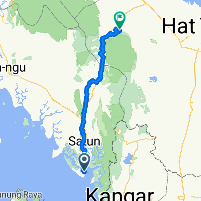
J17-Thaïlande-Tammalang-Thung Wa-13-03-2011
A cycling route starting in Satun, Satun, Thailand.
Overview
About this route
J17-Thailand
- -:--
- Duration
- 87.4 km
- Distance
- 166 m
- Ascent
- 150 m
- Descent
- ---
- Avg. speed
- ---
- Max. altitude
Route quality
Waytypes & surfaces along the route
Waytypes
Quiet road
14.9 km
(17 %)
Track
3.5 km
(4 %)
Surfaces
Paved
3.5 km
(4 %)
Unpaved
2.6 km
(3 %)
Asphalt
3.5 km
(4 %)
Unpaved (undefined)
2.6 km
(3 %)
Undefined
81.3 km
(93 %)
Continue with Bikemap
Use, edit, or download this cycling route
You would like to ride J17-Thaïlande-Tammalang-Thung Wa-13-03-2011 or customize it for your own trip? Here is what you can do with this Bikemap route:
Free features
- Save this route as favorite or in collections
- Copy & plan your own version of this route
- Split it into stages to create a multi-day tour
- Sync your route with Garmin or Wahoo
Premium features
Free trial for 3 days, or one-time payment. More about Bikemap Premium.
- Navigate this route on iOS & Android
- Export a GPX / KML file of this route
- Create your custom printout (try it for free)
- Download this route for offline navigation
Discover more Premium features.
Get Bikemap PremiumFrom our community
Other popular routes starting in Satun
 Satun - Krabi Ride
- Distance
- 263.5 km
- Ascent
- 326 m
- Descent
- 320 m
- Location
- Satun, Satun, Thailand
 SATUN to Krabi
- Distance
- 350.6 km
- Ascent
- 232 m
- Descent
- 208 m
- Location
- Satun, Satun, Thailand
 day 2 satun to Pak bara beach
- Distance
- 59.8 km
- Ascent
- 149 m
- Descent
- 148 m
- Location
- Satun, Satun, Thailand
 J17-Thaïlande-Tammalang-Thung Wa-13-03-2011
- Distance
- 87.4 km
- Ascent
- 166 m
- Descent
- 150 m
- Location
- Satun, Satun, Thailand
 Satun - Rattaphum
- Distance
- 84 km
- Ascent
- 405 m
- Descent
- 322 m
- Location
- Satun, Satun, Thailand
 Tam Malang-Pak Bara
- Distance
- 69.7 km
- Ascent
- 115 m
- Descent
- 111 m
- Location
- Satun, Satun, Thailand
 Satun Pak Nam
- Distance
- 64.2 km
- Ascent
- 119 m
- Descent
- 119 m
- Location
- Satun, Satun, Thailand
Open it in the app