

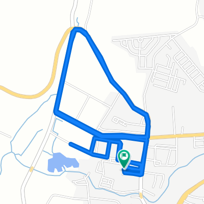
J26-Thaïlande_Ranong-Kra Buri-22-03-2011
A cycling route starting in Ranong, Ranong province, Thailand.
Overview
About this route
J26-Thailand Ranong-Kra Buri On 22-03-2011
- -:--
- Duration
- 71 km
- Distance
- 334 m
- Ascent
- 342 m
- Descent
- ---
- Avg. speed
- ---
- Max. altitude
Continue with Bikemap
Use, edit, or download this cycling route
You would like to ride J26-Thaïlande_Ranong-Kra Buri-22-03-2011 or customize it for your own trip? Here is what you can do with this Bikemap route:
Free features
- Save this route as favorite or in collections
- Copy & plan your own version of this route
- Sync your route with Garmin or Wahoo
Premium features
Free trial for 3 days, or one-time payment. More about Bikemap Premium.
- Navigate this route on iOS & Android
- Export a GPX / KML file of this route
- Create your custom printout (try it for free)
- Download this route for offline navigation
Discover more Premium features.
Get Bikemap PremiumFrom our community
Other popular routes starting in Ranong
 J26-Thaïlande_Ranong-Kra Buri-22-03-2011
- Distance
- 71 km
- Ascent
- 334 m
- Descent
- 342 m
- Location
- Ranong, Ranong province, Thailand
 Thailand, Tambon Khao Niwet to ถนน มหาราช, ตำบล ปากน้ำ
- Distance
- 340.6 km
- Ascent
- 6,022 m
- Descent
- 6,001 m
- Location
- Ranong, Ranong province, Thailand
 Petchkasem Road 160/1-14, Tambon Bang Rin to GG8X+QGH, Bang Hin
- Distance
- 58.8 km
- Ascent
- 359 m
- Descent
- 322 m
- Location
- Ranong, Ranong province, Thailand
 Soi Muban Ranong Village, Mueang Ranong to Soi Muban Ranong Village, Mueang Ranong
- Distance
- 13.7 km
- Ascent
- 284 m
- Descent
- 254 m
- Location
- Ranong, Ranong province, Thailand
 TH21 Ranong The b Ranong Trend Hotel - Kappoe Ranong Resort and Ragula
- Distance
- 66.7 km
- Ascent
- 978 m
- Descent
- 978 m
- Location
- Ranong, Ranong province, Thailand
 4. Ranong - Khao Lak village
- Distance
- 197.6 km
- Ascent
- 347 m
- Descent
- 358 m
- Location
- Ranong, Ranong province, Thailand
 myomintun
- Distance
- 110.9 km
- Ascent
- 2,219 m
- Descent
- 2,230 m
- Location
- Ranong, Ranong province, Thailand
 BSY Rundtour 6
- Distance
- 44.6 km
- Ascent
- 506 m
- Descent
- 428 m
- Location
- Ranong, Ranong province, Thailand
Open it in the app