

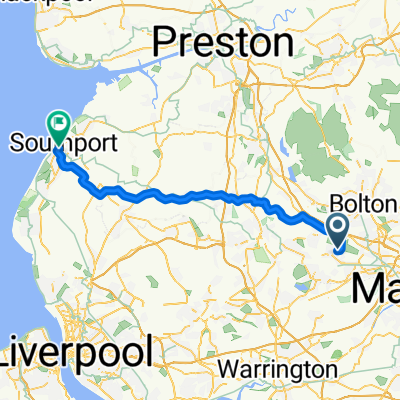
Atherton To Liverpol
A cycling route starting in Atherton, England, United Kingdom.
Overview
About this route
Pretty good route going from my hometown to favorite city. Atherton is a pretty central location along the east lancs, which has a good cycle lane. Going to test this track out tomorrow probably. Would do it on a mountain bike, but more suited for a road bike.
- -:--
- Duration
- 41.1 km
- Distance
- 131 m
- Ascent
- 167 m
- Descent
- ---
- Avg. speed
- ---
- Max. altitude
Continue with Bikemap
Use, edit, or download this cycling route
You would like to ride Atherton To Liverpol or customize it for your own trip? Here is what you can do with this Bikemap route:
Free features
- Save this route as favorite or in collections
- Copy & plan your own version of this route
- Sync your route with Garmin or Wahoo
Premium features
Free trial for 3 days, or one-time payment. More about Bikemap Premium.
- Navigate this route on iOS & Android
- Export a GPX / KML file of this route
- Create your custom printout (try it for free)
- Download this route for offline navigation
Discover more Premium features.
Get Bikemap PremiumFrom our community
Other popular routes starting in Atherton
 19 Hunt St, Manchester to Pine Tree Farm, Cutacre Way, Bolton
- Distance
- 5.5 km
- Ascent
- 58 m
- Descent
- 6 m
- Location
- Atherton, England, United Kingdom
 Atherton to Southport
- Distance
- 47.9 km
- Ascent
- 231 m
- Descent
- 296 m
- Location
- Atherton, England, United Kingdom
 Over Hulton Country Park Loop
- Distance
- 7.3 km
- Ascent
- 53 m
- Descent
- 62 m
- Location
- Atherton, England, United Kingdom
 Eckersley Fold Lane, Atherton to Schofield Lane, Atherton
- Distance
- 1.5 km
- Ascent
- 17 m
- Descent
- 0 m
- Location
- Atherton, England, United Kingdom
 Atherton to Blackpool
- Distance
- 165.1 km
- Ascent
- 544 m
- Descent
- 544 m
- Location
- Atherton, England, United Kingdom
 Keedie Day 6th August
- Distance
- 4.5 km
- Ascent
- 17 m
- Descent
- 70 m
- Location
- Atherton, England, United Kingdom
 Colliery Lane, Atherton to Leigh Road/Hartford Road, Westhoughton
- Distance
- 1 km
- Ascent
- 20 m
- Descent
- 0 m
- Location
- Atherton, England, United Kingdom
 Atherton To Liverpol
- Distance
- 41.1 km
- Ascent
- 131 m
- Descent
- 167 m
- Location
- Atherton, England, United Kingdom
Open it in the app