

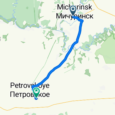
Иловай-2012
A cycling route starting in Michurinsk, Tambov Oblast, Russia.
Overview
About this route
Michurinsk - Khobotovo - Ilovay - New Garitovo - Petrovskoye
- -:--
- Duration
- 99.7 km
- Distance
- 156 m
- Ascent
- 166 m
- Descent
- ---
- Avg. speed
- ---
- Max. altitude

Route quality
Waytypes & surfaces along the route
Waytypes
Track
44.8 km
(45 %)
Road
19.9 km
(20 %)
Surfaces
Paved
35.9 km
(36 %)
Unpaved
49.8 km
(50 %)
Asphalt
35.9 km
(36 %)
Ground
29.9 km
(30 %)
Route highlights
Points of interest along the route
Point of interest after 37.6 km
Мини "Белая гора"
Point of interest after 37.9 km
Буреломинг - начало
Point of interest after 38.5 km
Буреломингу конец, дальше - траволоминг
Point of interest after 39.3 km
О, дорога! Можно ехать
Point of interest after 39.9 km
Ваще дорога!
Point of interest after 52.6 km
Начался песок
Point of interest after 54.9 km
Родник рядом с мостом
Point of interest after 58 km
Нижняя мельница (Усадьба)
Point of interest after 59.8 km
Родник у реки
Continue with Bikemap
Use, edit, or download this cycling route
You would like to ride Иловай-2012 or customize it for your own trip? Here is what you can do with this Bikemap route:
Free features
- Save this route as favorite or in collections
- Copy & plan your own version of this route
- Split it into stages to create a multi-day tour
- Sync your route with Garmin or Wahoo
Premium features
Free trial for 3 days, or one-time payment. More about Bikemap Premium.
- Navigate this route on iOS & Android
- Export a GPX / KML file of this route
- Create your custom printout (try it for free)
- Download this route for offline navigation
Discover more Premium features.
Get Bikemap PremiumFrom our community
Other popular routes starting in Michurinsk
 От улица Гоголевская 229, Мичуринск до Неизвестная дорога, Любовь
- Distance
- 49 km
- Ascent
- 150 m
- Descent
- 131 m
- Location
- Michurinsk, Tambov Oblast, Russia
 Новоникольское - Мичуринск
- Distance
- 24.3 km
- Ascent
- 102 m
- Descent
- 101 m
- Location
- Michurinsk, Tambov Oblast, Russia
 маршрут с Пионерская улица, 21, Мичуринск
- Distance
- 41.4 km
- Ascent
- 120 m
- Descent
- 99 m
- Location
- Michurinsk, Tambov Oblast, Russia
 Иловай-2012
- Distance
- 99.7 km
- Ascent
- 156 m
- Descent
- 166 m
- Location
- Michurinsk, Tambov Oblast, Russia
 От улица Интернатская 13г, Мичуринск до улица Новая 46, Мичуринск
- Distance
- 12 km
- Ascent
- 73 m
- Descent
- 77 m
- Location
- Michurinsk, Tambov Oblast, Russia
 От Липецкое шоссе 102Б, Мичуринск до Липецкое шоссе 110А, Мичуринск
- Distance
- 1.1 km
- Ascent
- 3 m
- Descent
- 0 m
- Location
- Michurinsk, Tambov Oblast, Russia
 Расслабленный маршрут
- Distance
- 3.2 km
- Ascent
- 58 m
- Descent
- 65 m
- Location
- Michurinsk, Tambov Oblast, Russia
 От улица Парковая 98, Мичуринск до Липецкое шоссе 68 корпус 2, Мичуринск
- Distance
- 19.5 km
- Ascent
- 176 m
- Descent
- 181 m
- Location
- Michurinsk, Tambov Oblast, Russia
Open it in the app