

From Brussels to Mignaloux-Beauvoir
Saint-Quentin - Argenteuil
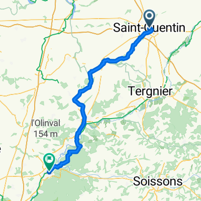
A cycling route starting in Saint-Quentin, Hauts-de-France, France.
Overview
About this route
0
- 9:34 h
- Duration
- 162.1 km
- Distance
- 1,012 m
- Ascent
- 1,051 m
- Descent
- 17 km/h
- Avg. speed
- 163 m
- Max. altitude
Noname Niname
created this 18 days ago
Part of
Route quality
Waytypes & surfaces along the route
Waytypes
Road
45.4 km
28 %
Quiet road
38.9 km
24 %
Surfaces
Paved
94 km
(58 %)
Unpaved
8.1 km
(5 %)
Asphalt
92.4 km
57 %
Gravel
6.5 km
4 %
Continue with Bikemap
Use, edit, or download this cycling route
You would like to ride Saint-Quentin - Argenteuil or customize it for your own trip? Here is what you can do with this Bikemap route:
Free features
- Save this route as favorite or in collections
- Copy & plan your own version of this route
- Split it into stages to create a multi-day tour
- Sync your route with Garmin or Wahoo
Premium features
Free trial for 3 days, or one-time payment. More about Bikemap Premium.
- Navigate this route on iOS & Android
- Export a GPX / KML file of this route
- Create your custom printout (try it for free)
- Download this route for offline navigation
Discover more Premium features.
Get Bikemap PremiumFrom our community
Other popular routes starting in Saint-Quentin
- Place de la Basilique nach Rue Robert Schuman0
- 83.3 km
- 341 m
- 458 m
- Saint-Quentin, Hauts-de-France, France


Open it in the app