

MTB _ Aubachtal-GPS
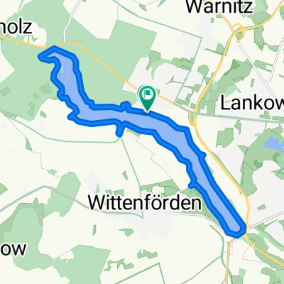
A cycling route starting in Wittenförden, Mecklenburg-Vorpommern, Germany.
Overview
About this route
<p>
MTB Tour, no major difficulties, F-Taler Forest, then the road to Barner Stück through the Aubach Valley.</p>
<p>
GPS recorded</p>
Translated, show original (German)- -:--
- Duration
- 28.4 km
- Distance
- 156 m
- Ascent
- 157 m
- Descent
- ---
- Avg. speed
- ---
- Max. altitude

Route quality
Waytypes & surfaces along the route
Waytypes
Path
9.1 km
(32 %)
Quiet road
8.8 km
(31 %)
Surfaces
Paved
10.2 km
(36 %)
Unpaved
14.5 km
(51 %)
Asphalt
9.1 km
(32 %)
Ground
9.1 km
(32 %)
Continue with Bikemap
Use, edit, or download this cycling route
You would like to ride MTB _ Aubachtal-GPS or customize it for your own trip? Here is what you can do with this Bikemap route:
Free features
- Save this route as favorite or in collections
- Copy & plan your own version of this route
- Sync your route with Garmin or Wahoo
Premium features
Free trial for 3 days, or one-time payment. More about Bikemap Premium.
- Navigate this route on iOS & Android
- Export a GPX / KML file of this route
- Create your custom printout (try it for free)
- Download this route for offline navigation
Discover more Premium features.
Get Bikemap PremiumFrom our community
Other popular routes starting in Wittenförden
 mdRzA 1.1.16
- Distance
- 22.7 km
- Ascent
- 75 m
- Descent
- 75 m
- Location
- Wittenförden, Mecklenburg-Vorpommern, Germany
 MTB - Neumühler See Natur pur CLONED FROM ROUTE 904585
- Distance
- 15.2 km
- Ascent
- 80 m
- Descent
- 81 m
- Location
- Wittenförden, Mecklenburg-Vorpommern, Germany
 MTB - Neumühler See Natur pur
- Distance
- 15.2 km
- Ascent
- 110 m
- Descent
- 111 m
- Location
- Wittenförden, Mecklenburg-Vorpommern, Germany
 Mühlen Eichsen und Innensee
- Distance
- 72.5 km
- Ascent
- 170 m
- Descent
- 170 m
- Location
- Wittenförden, Mecklenburg-Vorpommern, Germany
 Langer Nachmittag
- Distance
- 117.7 km
- Ascent
- 333 m
- Descent
- 334 m
- Location
- Wittenförden, Mecklenburg-Vorpommern, Germany
 Sportliche Route in Wittenförden
- Distance
- 10.6 km
- Ascent
- 44 m
- Descent
- 53 m
- Location
- Wittenförden, Mecklenburg-Vorpommern, Germany
 Spaziergang
- Distance
- 1.7 km
- Ascent
- 41 m
- Descent
- 42 m
- Location
- Wittenförden, Mecklenburg-Vorpommern, Germany
 Grambower Moor
- Distance
- 22.8 km
- Ascent
- 102 m
- Descent
- 97 m
- Location
- Wittenförden, Mecklenburg-Vorpommern, Germany
Open it in the app