

Cei - Prà dell'Albi
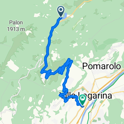
A cycling route starting in Pomarolo, Trentino-Alto Adige, Italy.
Overview
About this route
Alle prime case di Cei, al "Capitel di Doèra". To the right a paved road enters the woods, following the sign "Romanesque Church S.Martino".After 1.5 km of dense coppice forest with glimpses of marshy meadows, dry lake beds, another sign indicates the "Romanesque chapel" which is reached via an uphill path in about twenty minutes.Almost suddenly you are in front of a long and low building with a gently sloping gabled roof, propped on five pilasters like buttresses against the steep slope overlooking the Val d'Adige located 1000 meters below.The place exudes an atmosphere of solemn antiquity. Here tradition holds that in the Middle Ages, the only parish church for baptisms was located here - according to the legend - children were even brought here from the faraway Val di Cavedine beyond the crest of Stivo. This fact is still alive in the name "San Martino in Trasiel", which means in transit.Upon returning to the paved road, one should not miss a brief visit to the "Prà dell'Albi" where under two giant beech trees is a fountain with very fresh water. Today, this area has been designated as a biotope. It is a rich and dense marshland where various species of amphibians such as the alpine newt, the tree frog, the agile frog, and the spotted salamander can be found.
- -:--
- Duration
- 2.4 km
- Distance
- 102 m
- Ascent
- 74 m
- Descent
- ---
- Avg. speed
- ---
- Max. altitude

Route highlights
Points of interest along the route
Point of interest after 0 km
Capitel di Doèra
Point of interest after 1.2 km
Prà dell' Albi.
Point of interest after 2 km
Parcheggio per la chiesetta di S. Martino
Point of interest after 2.3 km
----> Strada per Malga Cimana
Point of interest after 2.4 km
Fontana di Prà dell'Albi
Continue with Bikemap
Use, edit, or download this cycling route
You would like to ride Cei - Prà dell'Albi or customize it for your own trip? Here is what you can do with this Bikemap route:
Free features
- Save this route as favorite or in collections
- Copy & plan your own version of this route
- Sync your route with Garmin or Wahoo
Premium features
Free trial for 3 days, or one-time payment. More about Bikemap Premium.
- Navigate this route on iOS & Android
- Export a GPX / KML file of this route
- Create your custom printout (try it for free)
- Download this route for offline navigation
Discover more Premium features.
Get Bikemap PremiumFrom our community
Other popular routes starting in Pomarolo
 Rovereto-Riva
- Distance
- 27.9 km
- Ascent
- 279 m
- Descent
- 419 m
- Location
- Pomarolo, Trentino-Alto Adige, Italy
 Nogaredo-Cei
- Distance
- 11.7 km
- Ascent
- 67 m
- Descent
- 827 m
- Location
- Pomarolo, Trentino-Alto Adige, Italy
 Giro coi Delaiti (corretto)
- Distance
- 27.3 km
- Ascent
- 1,251 m
- Descent
- 1,251 m
- Location
- Pomarolo, Trentino-Alto Adige, Italy
 Tour 3: Rovereto - Ferrara - Po Delta - Ravenna
- Distance
- 378.5 km
- Ascent
- 685 m
- Descent
- 911 m
- Location
- Pomarolo, Trentino-Alto Adige, Italy
 Bondone Fede
- Distance
- 43.8 km
- Ascent
- 2,002 m
- Descent
- 2,003 m
- Location
- Pomarolo, Trentino-Alto Adige, Italy
 POMA-Speck
- Distance
- 36.9 km
- Ascent
- 790 m
- Descent
- 909 m
- Location
- Pomarolo, Trentino-Alto Adige, Italy
 Malga Palazzo CR
- Distance
- 52.5 km
- Ascent
- 1,911 m
- Descent
- 498 m
- Location
- Pomarolo, Trentino-Alto Adige, Italy
 passo bordala e passo santa barbara
- Distance
- 51.8 km
- Ascent
- 1,682 m
- Descent
- 1,691 m
- Location
- Pomarolo, Trentino-Alto Adige, Italy
Open it in the app