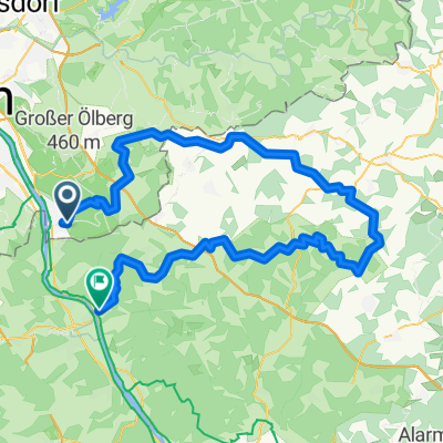
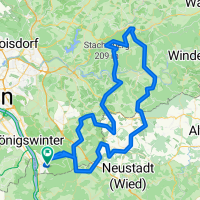
Rundkurs Söven groß
A cycling route starting in Bad Honnef, North Rhine-Westphalia, Germany.
Overview
About this route
Anstieg in Söven sehr ruhig und wenig steil, ansonsten stark befahrene Strecke
- -:--
- Duration
- 44.2 km
- Distance
- 526 m
- Ascent
- 541 m
- Descent
- ---
- Avg. speed
- 291 m
- Avg. speed
Route quality
Waytypes & surfaces along the route
Waytypes
Busy road
24.7 km
(56 %)
Quiet road
12 km
(27 %)
Surfaces
Paved
33.4 km
(75 %)
Unpaved
0.2 km
(<1 %)
Asphalt
32 km
(72 %)
Paving stones
0.6 km
(1 %)
Continue with Bikemap
Use, edit, or download this cycling route
You would like to ride Rundkurs Söven groß or customize it for your own trip? Here is what you can do with this Bikemap route:
Free features
- Save this route as favorite or in collections
- Copy & plan your own version of this route
- Sync your route with Garmin or Wahoo
Premium features
Free trial for 3 days, or one-time payment. More about Bikemap Premium.
- Navigate this route on iOS & Android
- Export a GPX / KML file of this route
- Create your custom printout (try it for free)
- Download this route for offline navigation
Discover more Premium features.
Get Bikemap PremiumFrom our community
Other popular routes starting in Bad Honnef
- Rhöndorf-Bad Honnef (W)
- Distance
- 13.2 km
- Ascent
- 472 m
- Descent
- 473 m
- Location
- Bad Honnef, North Rhine-Westphalia, Germany
- Ittenbach - Asberg
- Distance
- 17.7 km
- Ascent
- 341 m
- Descent
- 272 m
- Location
- Bad Honnef, North Rhine-Westphalia, Germany
- Honnef-Bonn-Sieg-Honnef
- Distance
- 43.3 km
- Ascent
- 28 m
- Descent
- 29 m
- Location
- Bad Honnef, North Rhine-Westphalia, Germany
- Siebengebirgstrail !!! 39km - 1300hm
- Distance
- 39 km
- Ascent
- 761 m
- Descent
- 765 m
- Location
- Bad Honnef, North Rhine-Westphalia, Germany
- Deine Mudda fährt hier lang
- Distance
- 10.2 km
- Ascent
- 352 m
- Descent
- 348 m
- Location
- Bad Honnef, North Rhine-Westphalia, Germany
- Sieben auf einen Streich
- Distance
- 17.1 km
- Ascent
- 615 m
- Descent
- 613 m
- Location
- Bad Honnef, North Rhine-Westphalia, Germany
- Leybergtrails
- Distance
- 19.6 km
- Ascent
- 670 m
- Descent
- 650 m
- Location
- Bad Honnef, North Rhine-Westphalia, Germany
- Himmerich über Mucherwiesental
- Distance
- 10.8 km
- Ascent
- 258 m
- Descent
- 257 m
- Location
- Bad Honnef, North Rhine-Westphalia, Germany
Open it in the app