
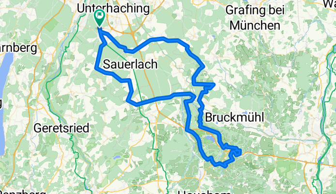
München - Irschenberg
A cycling route starting in Oberhaching, Bavaria, Germany.
Overview
About this route
- -:--
- Duration
- 116.3 km
- Distance
- 614 m
- Ascent
- 614 m
- Descent
- ---
- Avg. speed
- ---
- Avg. speed
Route quality
Waytypes & surfaces along the route
Waytypes
Quiet road
71.2 km
(61 %)
Road
25.5 km
(22 %)
Surfaces
Paved
107 km
(92 %)
Unpaved
0.7 km
(<1 %)
Asphalt
103.4 km
(89 %)
Paving stones
2.5 km
(2 %)
Continue with Bikemap
Use, edit, or download this cycling route
You would like to ride München - Irschenberg or customize it for your own trip? Here is what you can do with this Bikemap route:
Free features
- Save this route as favorite or in collections
- Copy & plan your own version of this route
- Split it into stages to create a multi-day tour
- Sync your route with Garmin or Wahoo
Premium features
Free trial for 3 days, or one-time payment. More about Bikemap Premium.
- Navigate this route on iOS & Android
- Export a GPX / KML file of this route
- Create your custom printout (try it for free)
- Download this route for offline navigation
Discover more Premium features.
Get Bikemap PremiumFrom our community
Other popular routes starting in Oberhaching
 Deisenhofen - Ascholding - Deisenh. (V1, ca 50km)
- Distance
- 47.4 km
- Ascent
- 434 m
- Descent
- 429 m
- Location
- Oberhaching, Bavaria, Germany
 Isartour gross
- Distance
- 56.9 km
- Ascent
- 413 m
- Descent
- 408 m
- Location
- Oberhaching, Bavaria, Germany
 Deisenhofen-Ascholding
- Distance
- 50.2 km
- Ascent
- 571 m
- Descent
- 570 m
- Location
- Oberhaching, Bavaria, Germany
 Deisenhofen-Egling
- Distance
- 63.6 km
- Ascent
- 710 m
- Descent
- 709 m
- Location
- Oberhaching, Bavaria, Germany
 Oberlandtour-62km-22
- Distance
- 61.3 km
- Ascent
- 90,391 m
- Descent
- 90,392 m
- Location
- Oberhaching, Bavaria, Germany
 Deisenhofen - Puppling
- Distance
- 52.8 km
- Ascent
- 340 m
- Descent
- 339 m
- Location
- Oberhaching, Bavaria, Germany
 Deisenhofen - Punding - Deisenh. (ca 62km)
- Distance
- 62.1 km
- Ascent
- 351 m
- Descent
- 351 m
- Location
- Oberhaching, Bavaria, Germany
 12.10.17 Mühlthal-Fahrt
- Distance
- 30.1 km
- Ascent
- 172 m
- Descent
- 208 m
- Location
- Oberhaching, Bavaria, Germany
Open it in the app