

Basel St.Brice
A cycling route starting in Basel, Canton of Basel-City, Switzerland.
Overview
About this route
Herrliche Waldstrecke mit technisch anspruchsvolleren Passagen.
Unbedingt in St.Brice Essen und Trinken!
Bei nasser Witterung sehr tiefer Boden.
- -:--
- Duration
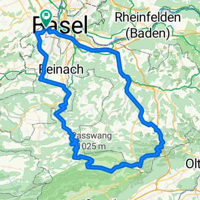
- 17.9 km
- Distance
- 400 m
- Ascent
- 211 m
- Descent
- ---
- Avg. speed
- ---
- Max. altitude

Route quality
Waytypes & surfaces along the route
Waytypes
Track
12.1 km
(68 %)
Path
2.3 km
(13 %)
Surfaces
Paved
3.9 km
(22 %)
Unpaved
11.1 km
(62 %)
Gravel
7.5 km
(42 %)
Ground
2.9 km
(16 %)
Continue with Bikemap
Use, edit, or download this cycling route
You would like to ride Basel St.Brice or customize it for your own trip? Here is what you can do with this Bikemap route:
Free features
- Save this route as favorite or in collections
- Copy & plan your own version of this route
- Sync your route with Garmin or Wahoo
Premium features
Free trial for 3 days, or one-time payment. More about Bikemap Premium.
- Navigate this route on iOS & Android
- Export a GPX / KML file of this route
- Create your custom printout (try it for free)
- Download this route for offline navigation
Discover more Premium features.
Get Bikemap PremiumFrom our community
Other popular routes starting in Basel
 Jura-Passrunde
- Distance
- 132.2 km
- Ascent
- 2,016 m
- Descent
- 2,019 m
- Location
- Basel, Canton of Basel-City, Switzerland
 Jura Route
- Distance
- 308.1 km
- Ascent
- 5,724 m
- Descent
- 5,212 m
- Location
- Basel, Canton of Basel-City, Switzerland
 Elsass-Birstal-Rundfahrt
- Distance
- 76.8 km
- Ascent
- 880 m
- Descent
- 840 m
- Location
- Basel, Canton of Basel-City, Switzerland
 1996_Rhein II (Oberrhein)
- Distance
- 407.3 km
- Ascent
- 49 m
- Descent
- 226 m
- Location
- Basel, Canton of Basel-City, Switzerland
 Basel-Hagethal-Oltige-Blochmont-Bourg-Därwil
- Distance
- 56.9 km
- Ascent
- 914 m
- Descent
- 855 m
- Location
- Basel, Canton of Basel-City, Switzerland
 Day 1: Preferred cycle track route: Basel SBB station to Kaisten/Laufenberg (Hotel: Mokka)
- Distance
- 53.5 km
- Ascent
- 479 m
- Descent
- 442 m
- Location
- Basel, Canton of Basel-City, Switzerland
 Oberbölchen-Passwang-Nunningen
- Distance
- 98.1 km
- Ascent
- 1,370 m
- Descent
- 1,370 m
- Location
- Basel, Canton of Basel-City, Switzerland
 find the 7
- Distance
- 47.9 km
- Ascent
- 590 m
- Descent
- 587 m
- Location
- Basel, Canton of Basel-City, Switzerland
Open it in the app