

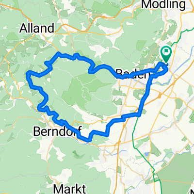
Wienerwaldsee-Runde
A cycling route starting in Traiskirchen, Lower Austria, Austria.
Overview
About this route
- -:--
- Duration
- 64.3 km
- Distance
- 507 m
- Ascent
- 507 m
- Descent
- ---
- Avg. speed
- ---
- Max. altitude

Route quality
Waytypes & surfaces along the route
Waytypes
Busy road
30.6 km
(48 %)
Road
11.2 km
(17 %)
Surfaces
Paved
52.1 km
(81 %)
Unpaved
3.1 km
(5 %)
Asphalt
51 km
(79 %)
Gravel
1.2 km
(2 %)
Continue with Bikemap
Use, edit, or download this cycling route
You would like to ride Wienerwaldsee-Runde or customize it for your own trip? Here is what you can do with this Bikemap route:
Free features
- Save this route as favorite or in collections
- Copy & plan your own version of this route
- Sync your route with Garmin or Wahoo
Premium features
Free trial for 3 days, or one-time payment. More about Bikemap Premium.
- Navigate this route on iOS & Android
- Export a GPX / KML file of this route
- Create your custom printout (try it for free)
- Download this route for offline navigation
Discover more Premium features.
Get Bikemap PremiumFrom our community
Other popular routes starting in Traiskirchen
 MTB_Guglzipf_2Hügel
- Distance
- 50.3 km
- Ascent
- 373 m
- Descent
- 363 m
- Location
- Traiskirchen, Lower Austria, Austria
 Traiskirchen - Laxenburg - Wien - Mödling
- Distance
- 46.8 km
- Ascent
- 125 m
- Descent
- 125 m
- Location
- Traiskirchen, Lower Austria, Austria
 TK Oberlaa Schwechat TK
- Distance
- 55 km
- Ascent
- 107 m
- Descent
- 105 m
- Location
- Traiskirchen, Lower Austria, Austria
 MTB_Helenental_Zobelh_Triesting
- Distance
- 58.1 km
- Ascent
- 522 m
- Descent
- 521 m
- Location
- Traiskirchen, Lower Austria, Austria
 Baden bei Wien Tour
- Distance
- 16.7 km
- Ascent
- 105 m
- Descent
- 102 m
- Location
- Traiskirchen, Lower Austria, Austria
 TR_Husarentempel
- Distance
- 13.9 km
- Ascent
- 331 m
- Descent
- 46 m
- Location
- Traiskirchen, Lower Austria, Austria
 Wien 10. - Laxenburg+
- Distance
- 44 km
- Ascent
- 116 m
- Descent
- 116 m
- Location
- Traiskirchen, Lower Austria, Austria
 Traiskirchen – Guglzipf Runde
- Distance
- 70.5 km
- Ascent
- 650 m
- Descent
- 651 m
- Location
- Traiskirchen, Lower Austria, Austria
Open it in the app