

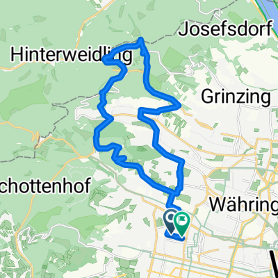
24) 8. Tour: 2012 Gerhard Wien- Ungarn- Slowenien- Raburg
A cycling route starting in Vienna, Vienna, Austria.
Overview
About this route
4 Tage
- Tag: WWbhf- Stotzinger-
Sieggrabener- Oberpullendorf
121,42 km
- Tag: Pullendorf- Körmend- Öriszentpetr
121,42 + 109,01 = 230,43 km
- Tag: Öriszentpetr- Raburg
230,43 + 52,87 = 283,3 km
- Tag: Therme- Spielfeld
283,3 + 38,46 = 321,76 km
HM
und wieder -138,71 m
Höhenmeter -10280
- -:--
- Duration
- 313.4 km
- Distance
- 878 m
- Ascent
- 829 m
- Descent
- ---
- Avg. speed
- ---
- Max. altitude

Continue with Bikemap
Use, edit, or download this cycling route
You would like to ride 24) 8. Tour: 2012 Gerhard Wien- Ungarn- Slowenien- Raburg or customize it for your own trip? Here is what you can do with this Bikemap route:
Free features
- Save this route as favorite or in collections
- Copy & plan your own version of this route
- Split it into stages to create a multi-day tour
- Sync your route with Garmin or Wahoo
Premium features
Free trial for 3 days, or one-time payment. More about Bikemap Premium.
- Navigate this route on iOS & Android
- Export a GPX / KML file of this route
- Create your custom printout (try it for free)
- Download this route for offline navigation
Discover more Premium features.
Get Bikemap PremiumFrom our community
Other popular routes starting in Vienna
 Vom Bikemap Office zum Kutschkermarkt
- Distance
- 5 km
- Ascent
- 64 m
- Descent
- 38 m
- Location
- Vienna, Vienna, Austria
 Boku-Exelberg-Sophie-Riederb-TulbingK-Königstetten-St-Andrae-Hintersd-Boku
- Distance
- 84.2 km
- Ascent
- 1,189 m
- Descent
- 1,189 m
- Location
- Vienna, Vienna, Austria
 Kaisermühlen Nationalpark Donau-Auen-Lobau nach Seestadt Aspern
- Distance
- 34.9 km
- Ascent
- 235 m
- Descent
- 241 m
- Location
- Vienna, Vienna, Austria
 MTB im wienerwald
- Distance
- 22.2 km
- Ascent
- 562 m
- Descent
- 560 m
- Location
- Vienna, Vienna, Austria
 Summer Event
- Distance
- 31.4 km
- Ascent
- 186 m
- Descent
- 185 m
- Location
- Vienna, Vienna, Austria
 Tour de Vienna
- Distance
- 22 km
- Ascent
- 105 m
- Descent
- 104 m
- Location
- Vienna, Vienna, Austria
 Augustiner- u Mostalmtrail über Sophienalpe
- Distance
- 32.1 km
- Ascent
- 540 m
- Descent
- 534 m
- Location
- Vienna, Vienna, Austria
 Blaue Leberkäsrunde: Donau-Prater(wirt)
- Distance
- 27.5 km
- Ascent
- 168 m
- Descent
- 180 m
- Location
- Vienna, Vienna, Austria
Open it in the app