

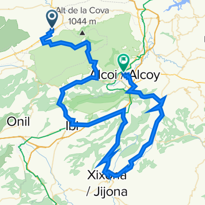
Bocairent - (Guilella) - Banyeres - (serra) - Biar - La Canyada - Beneixama - Bocairent
A cycling route starting in Bocairent, Valencia, Spain.
Overview
About this route
Ruta molt recomanable que comença a Bocairent i atravessa les poblacions de Banyeres de Mariola, Biar, La Canyada, Camp de Mirra i Beneixama, a més de passar per zones precioses com és el paratge natural de la Serra de Mariola, el naixement del riu Vinalopó, o la Serra de Biar. Combina asfalt i grava en un 30% - 70% respectivament. Dificultat alta per la longitud de la ruta. Requereix unes 3 hores.
- -:--
- Duration
- 59.8 km
- Distance
- 646 m
- Ascent
- 623 m
- Descent
- ---
- Avg. speed
- ---
- Max. altitude
Route quality
Waytypes & surfaces along the route
Waytypes
Track
26.3 km
(44 %)
Quiet road
17.8 km
(30 %)
Surfaces
Paved
6.9 km
(11 %)
Unpaved
10.9 km
(18 %)
Unpaved (undefined)
6.2 km
(10 %)
Gravel
4.7 km
(8 %)
Continue with Bikemap
Use, edit, or download this cycling route
You would like to ride Bocairent - (Guilella) - Banyeres - (serra) - Biar - La Canyada - Beneixama - Bocairent or customize it for your own trip? Here is what you can do with this Bikemap route:
Free features
- Save this route as favorite or in collections
- Copy & plan your own version of this route
- Sync your route with Garmin or Wahoo
Premium features
Free trial for 3 days, or one-time payment. More about Bikemap Premium.
- Navigate this route on iOS & Android
- Export a GPX / KML file of this route
- Create your custom printout (try it for free)
- Download this route for offline navigation
Discover more Premium features.
Get Bikemap PremiumFrom our community
Other popular routes starting in Bocairent
 Bocairent - Alcoy
- Distance
- 93.7 km
- Ascent
- 1,909 m
- Descent
- 1,993 m
- Location
- Bocairent, Valencia, Spain
 Bocairent-Agres-OF Teix-Muro-VV Yecla
- Distance
- 47.7 km
- Ascent
- 921 m
- Descent
- 924 m
- Location
- Bocairent, Valencia, Spain
 Bocairent - Villalonga
- Distance
- 61.5 km
- Ascent
- 638 m
- Descent
- 716 m
- Location
- Bocairent, Valencia, Spain
 5 Bocairen-Mariola-Gandia1 75km
- Distance
- 76.1 km
- Ascent
- 813 m
- Descent
- 1,420 m
- Location
- Bocairent, Valencia, Spain
 Estació Bocairent-Estació L'Orxa (Xixarra IIII)
- Distance
- 35.9 km
- Ascent
- 124 m
- Descent
- 465 m
- Location
- Bocairent, Valencia, Spain
 BOCAIRENT-SIERRA DE MARIOLA
- Distance
- 41.2 km
- Ascent
- 584 m
- Descent
- 560 m
- Location
- Bocairent, Valencia, Spain
 Bocairent - (Guilella) - Banyeres - (serra) - Biar - La Canyada - Beneixama - Bocairent
- Distance
- 59.8 km
- Ascent
- 646 m
- Descent
- 623 m
- Location
- Bocairent, Valencia, Spain
 Rondrit vanuit Bocairent
- Distance
- 57.2 km
- Ascent
- 983 m
- Descent
- 984 m
- Location
- Bocairent, Valencia, Spain
Open it in the app