

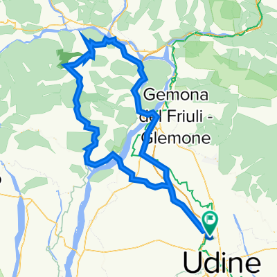
attimis-subit-taipana-nimis
A cycling route starting in Feletto Umberto, Friuli Venezia Giulia, Italy.
Overview
About this route
ATTENZIONE: il tratto che va da Subit all'incrocio con la strada principale di Platischis, pur essendo asfaltato, è molto sconnesso, con buche, ghiaino e detriti vari. Percoso da farsi preferibilmente con bici da trekking o con copertoncini da ciclocross.
WARNING: the way from Subit to the junction with the main road from Platischis, although asphalted is very bumpy, with potholes, gravel and various dirt. Itinerary to be done preferably with trekking bikes or cyclocross tires.
- -:--
- Duration
- 62 km
- Distance
- 832 m
- Ascent
- 832 m
- Descent
- ---
- Avg. speed
- ---
- Max. altitude

Route quality
Waytypes & surfaces along the route
Waytypes
Road
26 km
(42 %)
Quiet road
18 km
(29 %)
Surfaces
Paved
40.3 km
(65 %)
Unpaved
0.6 km
(1 %)
Asphalt
40.3 km
(65 %)
Gravel
0.6 km
(1 %)
Undefined
21.1 km
(34 %)
Continue with Bikemap
Use, edit, or download this cycling route
You would like to ride attimis-subit-taipana-nimis or customize it for your own trip? Here is what you can do with this Bikemap route:
Free features
- Save this route as favorite or in collections
- Copy & plan your own version of this route
- Sync your route with Garmin or Wahoo
Premium features
Free trial for 3 days, or one-time payment. More about Bikemap Premium.
- Navigate this route on iOS & Android
- Export a GPX / KML file of this route
- Create your custom printout (try it for free)
- Download this route for offline navigation
Discover more Premium features.
Get Bikemap PremiumFrom our community
Other popular routes starting in Feletto Umberto
 attimis-subit-taipana-nimis
- Distance
- 62 km
- Ascent
- 832 m
- Descent
- 832 m
- Location
- Feletto Umberto, Friuli Venezia Giulia, Italy
 Cuel di Forchia da Avasinis
- Distance
- 96.6 km
- Ascent
- 1,093 m
- Descent
- 1,089 m
- Location
- Feletto Umberto, Friuli Venezia Giulia, Italy
 Lungo 2011
- Distance
- 153.6 km
- Ascent
- 1,998 m
- Descent
- 1,997 m
- Location
- Feletto Umberto, Friuli Venezia Giulia, Italy
 lig da kanal
- Distance
- 117.9 km
- Ascent
- 1,187 m
- Descent
- 1,187 m
- Location
- Feletto Umberto, Friuli Venezia Giulia, Italy
 mercoledì 1 maggio CBteam
- Distance
- 117.5 km
- Ascent
- 1,272 m
- Descent
- 1,282 m
- Location
- Feletto Umberto, Friuli Venezia Giulia, Italy
 Valli del Natisone - Cladrecis-Restocina-Craoretto
- Distance
- 68.9 km
- Ascent
- 432 m
- Descent
- 432 m
- Location
- Feletto Umberto, Friuli Venezia Giulia, Italy
 attraverso il collio italiano e sloveno
- Distance
- 107.6 km
- Ascent
- 929 m
- Descent
- 929 m
- Location
- Feletto Umberto, Friuli Venezia Giulia, Italy
 val d'arzino-sella chianzutan-cavazzo
- Distance
- 112.9 km
- Ascent
- 1,091 m
- Descent
- 1,088 m
- Location
- Feletto Umberto, Friuli Venezia Giulia, Italy
Open it in the app