

High School to Exit 179/65
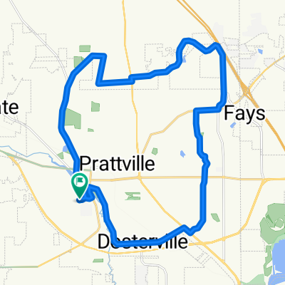
A cycling route starting in Prattville, Alabama, United States.
Overview
About this route
Great paved ride with back roads and low traffic during off peak hours.
- -:--
- Duration
- 29.2 km
- Distance
- 204 m
- Ascent
- 204 m
- Descent
- ---
- Avg. speed
- ---
- Max. altitude

Route quality
Waytypes & surfaces along the route
Waytypes
Road
19.2 km
(66 %)
Quiet road
7.6 km
(26 %)
Surfaces
Paved
1.7 km
(6 %)
Asphalt
1.7 km
(6 %)
Undefined
27.4 km
(94 %)
Continue with Bikemap
Use, edit, or download this cycling route
You would like to ride High School to Exit 179/65 or customize it for your own trip? Here is what you can do with this Bikemap route:
Free features
- Save this route as favorite or in collections
- Copy & plan your own version of this route
- Sync your route with Garmin or Wahoo
Premium features
Free trial for 3 days, or one-time payment. More about Bikemap Premium.
- Navigate this route on iOS & Android
- Export a GPX / KML file of this route
- Create your custom printout (try it for free)
- Download this route for offline navigation
Discover more Premium features.
Get Bikemap PremiumFrom our community
Other popular routes starting in Prattville
 Around Town with Hills
- Distance
- 60 km
- Ascent
- 342 m
- Descent
- 346 m
- Location
- Prattville, Alabama, United States
 Prattville to Clanton Ride
- Distance
- 121.6 km
- Ascent
- 548 m
- Descent
- 538 m
- Location
- Prattville, Alabama, United States
 Recovered Route
- Distance
- 8.5 km
- Ascent
- 46 m
- Descent
- 36 m
- Location
- Prattville, Alabama, United States
 Doug's route 27.6km
- Distance
- 27.6 km
- Ascent
- 197 m
- Descent
- 198 m
- Location
- Prattville, Alabama, United States
 UpKingLoop3
- Distance
- 28.2 km
- Ascent
- 231 m
- Descent
- 232 m
- Location
- Prattville, Alabama, United States
 Prattville High School to Possom Trot
- Distance
- 77.8 km
- Ascent
- 338 m
- Descent
- 338 m
- Location
- Prattville, Alabama, United States
 Prattville High to Deatsville
- Distance
- 59.1 km
- Ascent
- 299 m
- Descent
- 299 m
- Location
- Prattville, Alabama, United States
 North Memorial Drive 1007, Prattville to North Memorial Drive 1007, Prattville
- Distance
- 58.2 km
- Ascent
- 304 m
- Descent
- 340 m
- Location
- Prattville, Alabama, United States
Open it in the app