
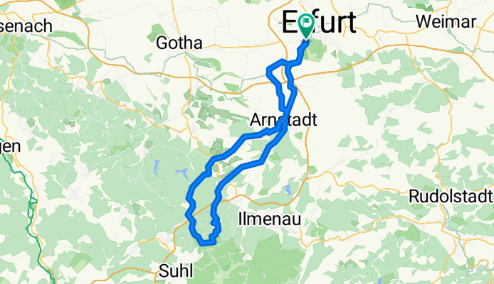
Erfurt - Arn - Schmücke - Jonastal - Molsdorf - Erfurt
A cycling route starting in Erfurt, Thuringia, Germany.
Overview
About this route
3x Pflasterstraße enthalten:
Arn / Molsdorf /bei Plaue
Anfahrt zum dezenten Bergtraining und reichlich Abtrieb zur kurvenreichen Abfahrt, lang auslaufen lassen.
war die spontane Himmelfahrtstour mit Bikern des MTB-Erfurt, ich weiß bis heute nicht wer die Raserei auf dem Heimweg angezettelt hat x)
- -:--
- Duration
- 102.6 km
- Distance
- 1,045 m
- Ascent
- 965 m
- Descent
- ---
- Avg. speed
- 943 m
- Max. altitude

Route quality
Waytypes & surfaces along the route
Waytypes
Busy road
45.1 km
(44 %)
Road
27.9 km
(27 %)
Surfaces
Paved
87.4 km
(85 %)
Unpaved
5.4 km
(5 %)
Asphalt
79.7 km
(78 %)
Paving stones
6.9 km
(7 %)
Continue with Bikemap
Use, edit, or download this cycling route
You would like to ride Erfurt - Arn - Schmücke - Jonastal - Molsdorf - Erfurt or customize it for your own trip? Here is what you can do with this Bikemap route:
Free features
- Save this route as favorite or in collections
- Copy & plan your own version of this route
- Split it into stages to create a multi-day tour
- Sync your route with Garmin or Wahoo
Premium features
Free trial for 3 days, or one-time payment. More about Bikemap Premium.
- Navigate this route on iOS & Android
- Export a GPX / KML file of this route
- Create your custom printout (try it for free)
- Download this route for offline navigation
Discover more Premium features.
Get Bikemap PremiumFrom our community
Other popular routes starting in Erfurt
 Erfurter Wesrrunde
- Distance
- 71.8 km
- Ascent
- 371 m
- Descent
- 374 m
- Location
- Erfurt, Thuringia, Germany
 Storchmühlenweg 17, Erfurt nach Karlstraße 10b, Erfurt
- Distance
- 19.5 km
- Ascent
- 141 m
- Descent
- 145 m
- Location
- Erfurt, Thuringia, Germany
 Stadtradeln 04.06.2021
- Distance
- 57.7 km
- Ascent
- 148 m
- Descent
- 148 m
- Location
- Erfurt, Thuringia, Germany
 Kleine Abendrunde mit Bergen
- Distance
- 29.3 km
- Ascent
- 404 m
- Descent
- 404 m
- Location
- Erfurt, Thuringia, Germany
 Erfurt Westlich von Erfurt mit dem Rennrad
- Distance
- 52.3 km
- Ascent
- 222 m
- Descent
- 223 m
- Location
- Erfurt, Thuringia, Germany
 Lutherstein Tour
- Distance
- 45.8 km
- Ascent
- 133 m
- Descent
- 143 m
- Location
- Erfurt, Thuringia, Germany
 Tour zum Riechheimer Berg
- Distance
- 43 km
- Ascent
- 628 m
- Descent
- 559 m
- Location
- Erfurt, Thuringia, Germany
 Erfurt - Arn - Schmücke - Jonastal - Molsdorf - Erfurt
- Distance
- 102.6 km
- Ascent
- 1,045 m
- Descent
- 965 m
- Location
- Erfurt, Thuringia, Germany
Open it in the app