

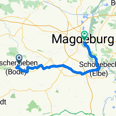
Oschersleben-Magdeburg (lang)
- 59 km
- 80 m
- 118 m
- Oschersleben, Saxony-Anhalt, Germany
A cycling route starting in Oschersleben, Saxony-Anhalt, Germany.
Overview
Start 06:50Finish 20:21Travel time 09:09unfortunately, the GPX track is so large that the import doesn’t work, so some points had to be removed, as it is a bit rougher.Nice weather on 20.10.2012
Route quality
Track
83.1 km
53 %
Quiet road
20.4 km
13 %
Paved
45.5 km
(29 %)
Unpaved
73.7 km
(47 %)
Gravel
40.8 km
26 %
Asphalt
29.8 km
19 %
Route highlights
am Geotop mal links runter?
links den Trail runter? also von oben rechts fahren
rechts gehts auch lang
schöner Trail
entweder links neben der Straße oder hoch am Klingenberg den Pfad folgen
auch ne Möglichkeit Grenzweg hoch
Fuchsfarm umfahren, Weg war schlammig
oder hier rüber
Continue with Bikemap
You would like to ride Tour mit Patrick, Christian, Jürgen und Erich or customize it for your own trip? Here is what you can do with this Bikemap route:
Free trial for 3 days, or one-time payment. More about Bikemap Premium.
Discover more Premium features.
Get Bikemap PremiumFrom our community
Open it in the app


