
Bäldleschweige-Ellgau-Oberndorf
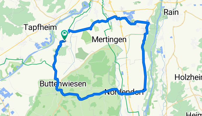
A cycling route starting in Tapfheim, Bavaria, Germany.
Overview
About this route
Start vom Parkplatz Bäldleschweige in Richtung Pfaffenhofen. Einzige nennenswerte Steigung bei Vorderried. Die Strecke verläuft größtenteils im Bereich Donauried und unteres Lechtal auf wenig befahrenen Straßen und Radwegen entlang der Straßen.
Am Ende winkt der Biergarten Bäldleschweige.Fahrzeit ca. 2.10 Std.
- -:--
- Duration
- 44.7 km
- Distance
- 91 m
- Ascent
- 92 m
- Descent
- ---
- Avg. speed
- 460 m
- Max. altitude
Route quality
Waytypes & surfaces along the route
Waytypes
Road
28.5 km
(64 %)
Quiet road
9 km
(20 %)
Surfaces
Paved
41.3 km
(92 %)
Unpaved
0.3 km
(<1 %)
Asphalt
41.2 km
(92 %)
Ground
0.2 km
(<1 %)
Continue with Bikemap
Use, edit, or download this cycling route
You would like to ride Bäldleschweige-Ellgau-Oberndorf or customize it for your own trip? Here is what you can do with this Bikemap route:
Free features
- Save this route as favorite or in collections
- Copy & plan your own version of this route
- Sync your route with Garmin or Wahoo
Premium features
Free trial for 3 days, or one-time payment. More about Bikemap Premium.
- Navigate this route on iOS & Android
- Export a GPX / KML file of this route
- Create your custom printout (try it for free)
- Download this route for offline navigation
Discover more Premium features.
Get Bikemap PremiumFrom our community
Other popular routes starting in Tapfheim
 Gerda-Tour
- Distance
- 74.8 km
- Ascent
- 141 m
- Descent
- 162 m
- Location
- Tapfheim, Bavaria, Germany
 Tapfheim nach Bürgermeister-Müller-Straße 3, Asbach-Bäumenheim
- Distance
- 10.5 km
- Ascent
- 10 m
- Descent
- 10 m
- Location
- Tapfheim, Bavaria, Germany
 Donau
Donau- Distance
- 48.4 km
- Ascent
- 50 m
- Descent
- 52 m
- Location
- Tapfheim, Bavaria, Germany
 Kesseltal-Harburg-Wertingen-Buttenwiesen
- Distance
- 105 km
- Ascent
- 813 m
- Descent
- 799 m
- Location
- Tapfheim, Bavaria, Germany
 2.Etappe Hamburg
- Distance
- 83.2 km
- Ascent
- 293 m
- Descent
- 242 m
- Location
- Tapfheim, Bavaria, Germany
 Bäldleschwaig<->Binswangen
- Distance
- 41.5 km
- Ascent
- 47 m
- Descent
- 48 m
- Location
- Tapfheim, Bavaria, Germany
 7Kapellen-2
- Distance
- 57.6 km
- Ascent
- 574 m
- Descent
- 551 m
- Location
- Tapfheim, Bavaria, Germany
 Riedstraße 16E, Tapfheim nach Bäckerstraße 18, Tapfheim
- Distance
- 17.5 km
- Ascent
- 163 m
- Descent
- 155 m
- Location
- Tapfheim, Bavaria, Germany
Open it in the app