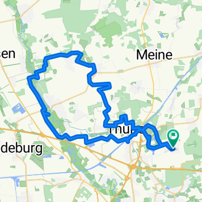
Waggum-Gifh.Didderse
A cycling route starting in Bevenrode, Lower Saxony, Germany.
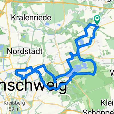
Overview
About this route
Route for a relaxed ride with a mountain or trekking bike.
Route description
approx. 40 km with 110 m of elevation gain
Easy route: large portion on paved field and bike paths or through villages, many meadow paths and trails; the most difficult section is the approx. 400 m field passage near Adenbüttel (push section possible depending on crop cultivation). Near Groß Schwülper a short detour to the Oker river. There is a nice bathing spot there.<br /><br />Push section can be avoided: At the entrance to Adenbüttel, do not cross the street 'Auf der Heide', but turn left and then at 'Gifhorner Str.' turn right and follow the road for about 860 m.
- -:--
- Duration
- 39.4 km
- Distance
- 106 m
- Ascent
- 106 m
- Descent
- ---
- Avg. speed
- ---
- Max. altitude
Route quality
Waytypes & surfaces along the route
Waytypes
Track
22.1 km
(56 %)
Quiet road
6.7 km
(17 %)
Surfaces
Paved
16.5 km
(42 %)
Unpaved
16.5 km
(42 %)
Asphalt
16.2 km
(41 %)
Gravel
9.5 km
(24 %)
Continue with Bikemap
Use, edit, or download this cycling route
You would like to ride Waggum-Gifh.Didderse or customize it for your own trip? Here is what you can do with this Bikemap route:
Free features
- Save this route as favorite or in collections
- Copy & plan your own version of this route
- Sync your route with Garmin or Wahoo
Premium features
Free trial for 3 days, or one-time payment. More about Bikemap Premium.
- Navigate this route on iOS & Android
- Export a GPX / KML file of this route
- Create your custom printout (try it for free)
- Download this route for offline navigation
Discover more Premium features.
Get Bikemap PremiumFrom our community
Other popular routes starting in Bevenrode
- BS-West BS-Ost
- Distance
- 69.1 km
- Ascent
- 102 m
- Descent
- 89 m
- Location
- Bevenrode, Lower Saxony, Germany
- Ruta relajada en essenrode
- Distance
- 13.4 km
- Ascent
- 101 m
- Descent
- 133 m
- Location
- Bevenrode, Lower Saxony, Germany
- WOB Mörse-Flechtorf-Hondelage
- Distance
- 50.2 km
- Ascent
- 224 m
- Descent
- 225 m
- Location
- Bevenrode, Lower Saxony, Germany
- 2025.05.22 - Dibbesdorf-Gliesmarode-Ringgleis-Riddagshausen-Dibbesdorf
- Distance
- 30.2 km
- Ascent
- 68 m
- Descent
- 69 m
- Location
- Bevenrode, Lower Saxony, Germany
- Waggum-Gifh.Didderse
- Distance
- 39.4 km
- Ascent
- 106 m
- Descent
- 106 m
- Location
- Bevenrode, Lower Saxony, Germany
- 2025.05.08 - Dibbesdorf-Thune Spargelhof-Dalmacija-Wenden-Rühme-Querum-Dibbesdorf
- Distance
- 26.6 km
- Ascent
- 63 m
- Descent
- 64 m
- Location
- Bevenrode, Lower Saxony, Germany
- BS-Ost (Elm)
- Distance
- 76.7 km
- Ascent
- 430 m
- Descent
- 439 m
- Location
- Bevenrode, Lower Saxony, Germany
- Erweiterung der schattigen Waldtour - Braunschweig Nordost
- Distance
- 19.7 km
- Ascent
- 77 m
- Descent
- 95 m
- Location
- Bevenrode, Lower Saxony, Germany
Open it in the app