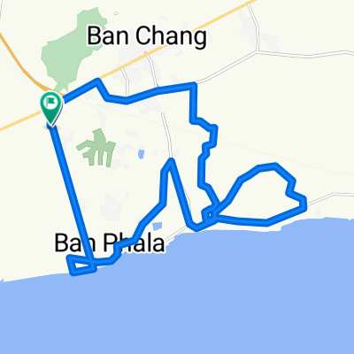
ชบ. 1003, Amphoe Sattahip to ชบ. 1003, Amphoe Sattahip
- 17.4 km
- 377 m
- 381 m
- Ban Chang, Rayong, Thailand
A cycling route starting in Ban Chang, Rayong, Thailand.
Overview
Beginning on Taesaban 2/1 just Wast and North of the Eastern Star Resort West entrance, the route heads South to the beach then East paralleling the Gulf toward MapTaPut utilizing country sois with low volumne traffic. The route turns North headed toward Sukhumvit Rd before reaching Maptaput then heads back to the West toward the starting point. The roads are primarily flat and 99% paved. Suitable for both mountain and road bikes. The route travels through some eucalyptus and mango plantations and mostly country side.
created this 13 years ago
Route highlights
Beginning on Taesaban 2/1 just Wast and North of the Eastern Star Resort West entrance, the route heads South to the beach then East paralleling the Gulf toward MapTaPut utilizing country sois with low volumne traffic. The route turns North headed toward Sukhumvit Rd before reaching Maptaput then heads back to the West toward the starting point. The roads are primarily flat and 99% paved. Suitable for both mountain and road bikes. The route travels through some eucalyptus and mango plantations and mostly country side.
Continue with Bikemap
You would like to ride MTS Solo Route or customize it for your own trip? Here is what you can do with this Bikemap route:
Free trial for 3 days, or one-time payment. More about Bikemap Premium.
Discover more Premium features.
Get Bikemap PremiumFrom our community
Open it in the app