

2012 French Tour -- Ride Day 60 -- 28 October 2012 -- Albi to Blagnac (Toulouse)
A cycling route starting in Albi, Occitanie, France.
Overview
About this route
To be added later...
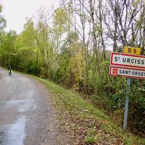
Most of the roads today were excellent low-traffic roads. The exceptions were D988 from Marssac to D18 and all of D2. While D2 was the best there was, plus it did have some bike lane, it would be best to try to find alternatives to this section of D988. The second portion of D988 and D888 were pretty good riding with much of it having some shoulder. Along a good portion of both sides of D988 was a seemingly never-ending corridor of plane trees.
Having made the above comment on the roads, our ride today was one hard slog. While we had nice sunshine, we had a strong cold and gusty wind from the west that with today's low temperatures both kept us moving at a very slow pace and sapped our energy. It also made our knees ache. While under normal circumstances, we would have arrived an hour or two before sunset, today we only arrived maybe twenty or thirty minutes after sunset. And we studiously try to avoid riding at night. Otherwise, a great ride. <div><br /></div>
- -:--
- Duration
- 97 km
- Distance
- 243 m
- Ascent
- 268 m
- Descent
- ---
- Avg. speed
- ---
- Max. altitude

Route quality
Waytypes & surfaces along the route
Waytypes
Road
37.8 km
(39 %)
Quiet road
17.5 km
(18 %)
Surfaces
Paved
28.1 km
(29 %)
Asphalt
27.2 km
(28 %)
Paved (undefined)
1 km
(1 %)
Undefined
68.9 km
(71 %)
Continue with Bikemap
Use, edit, or download this cycling route
You would like to ride 2012 French Tour -- Ride Day 60 -- 28 October 2012 -- Albi to Blagnac (Toulouse) or customize it for your own trip? Here is what you can do with this Bikemap route:
Free features
- Save this route as favorite or in collections
- Copy & plan your own version of this route
- Split it into stages to create a multi-day tour
- Sync your route with Garmin or Wahoo
Premium features
Free trial for 3 days, or one-time payment. More about Bikemap Premium.
- Navigate this route on iOS & Android
- Export a GPX / KML file of this route
- Create your custom printout (try it for free)
- Download this route for offline navigation
Discover more Premium features.
Get Bikemap PremiumFrom our community
Other popular routes starting in Albi
 2012 French Tour -- Ride Day 59 -- 25 October 2012 -- Albi -- Circle
- Distance
- 54.3 km
- Ascent
- 622 m
- Descent
- 622 m
- Location
- Albi, Occitanie, France
 2014 Ride Day 103 - Albi to Montauban
- Distance
- 74.1 km
- Ascent
- 387 m
- Descent
- 439 m
- Location
- Albi, Occitanie, France
 2012 French Tour -- Ride Day 58 -- 23 October 2012 -- Albi -- Circle
- Distance
- 100.3 km
- Ascent
- 997 m
- Descent
- 999 m
- Location
- Albi, Occitanie, France
 Rue de l'Ort en Salvy nach D9
- Distance
- 43.1 km
- Ascent
- 743 m
- Descent
- 777 m
- Location
- Albi, Occitanie, France
 2012 French Tour -- Ride Day 60 -- 28 October 2012 -- Albi to Blagnac (Toulouse)
- Distance
- 97 km
- Ascent
- 243 m
- Descent
- 268 m
- Location
- Albi, Occitanie, France
 Saint-Juéry - côte de Saint-Sernin
- Distance
- 98.6 km
- Ascent
- 3,184 m
- Descent
- 3,179 m
- Location
- Albi, Occitanie, France
 Albi to Montauban
- Distance
- 75.4 km
- Ascent
- 968 m
- Descent
- 1,022 m
- Location
- Albi, Occitanie, France
 **17-X. Albi - Saint Flour (197,5 Km)
- Distance
- 197.3 km
- Ascent
- 3,336 m
- Descent
- 2,707 m
- Location
- Albi, Occitanie, France
Open it in the app