

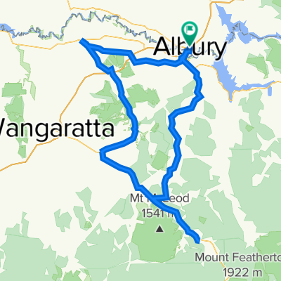
Alpine Way Australia
A cycling route starting in South Albury, New South Wales, Australia.
Overview
About this route
- -:--
- Duration
- 343.6 km
- Distance
- 2,677 m
- Ascent
- 2,025 m
- Descent
- ---
- Avg. speed
- ---
- Max. altitude

Route quality
Waytypes & surfaces along the route
Waytypes
Busy road
319.2 km
(93 %)
Access road
6.6 km
(2 %)
Surfaces
Paved
333.9 km
(97 %)
Unpaved
3.6 km
(1 %)
Asphalt
324.1 km
(94 %)
Paved (undefined)
7.8 km
(2 %)
Route highlights
Points of interest along the route
Point of interest after 222.1 km
Tasmanian Wilderness, UN
Point of interest after 222.1 km
Lavender Fields
Point of interest after 222.1 km
Brickendon - Wolmers estates - UN
Point of interest after 222.1 km
Cascades female factory
Point of interest after 222.1 km
Woolmers Estate
Point of interest after 222.1 km
Port Arthur historic site, UN
Point of interest after 222.1 km
Coal Mines historic UN
Point of interest after 222.1 km
Darlington probation station, UN
Point of interest after 241.4 km
Kosciuszko
Continue with Bikemap
Use, edit, or download this cycling route
You would like to ride Alpine Way Australia or customize it for your own trip? Here is what you can do with this Bikemap route:
Free features
- Save this route as favorite or in collections
- Copy & plan your own version of this route
- Split it into stages to create a multi-day tour
- Sync your route with Garmin or Wahoo
Premium features
Free trial for 3 days, or one-time payment. More about Bikemap Premium.
- Navigate this route on iOS & Android
- Export a GPX / KML file of this route
- Create your custom printout (try it for free)
- Download this route for offline navigation
Discover more Premium features.
Get Bikemap PremiumFrom our community
Other popular routes starting in South Albury
 56 Lincoln Causeway, Gateway Island to 576 Hume Street, Albury
- Distance
- 16.7 km
- Ascent
- 59 m
- Descent
- 65 m
- Location
- South Albury, New South Wales, Australia
 Albury - Garden Island Gateway Trail
- Distance
- 11 km
- Ascent
- 180 m
- Descent
- 179 m
- Location
- South Albury, New South Wales, Australia
 Alpine Way Australia
- Distance
- 343.6 km
- Ascent
- 2,677 m
- Descent
- 2,025 m
- Location
- South Albury, New South Wales, Australia
 Kiewa Street, Albury to 1112 Botany Road, Botany
- Distance
- 649.4 km
- Ascent
- 8,212 m
- Descent
- 8,368 m
- Location
- South Albury, New South Wales, Australia
 Lincoln Causeway 54, Gateway Island to Lemke Road 68, Gateway Island
- Distance
- 4.6 km
- Ascent
- 65 m
- Descent
- 62 m
- Location
- South Albury, New South Wales, Australia
 Victorian Circuit
- Distance
- 271.4 km
- Ascent
- 1,135 m
- Descent
- 1,135 m
- Location
- South Albury, New South Wales, Australia
 Albury to Khancoban
- Distance
- 155.4 km
- Ascent
- 1,093 m
- Descent
- 917 m
- Location
- South Albury, New South Wales, Australia
 Legal work route
- Distance
- 6.8 km
- Ascent
- 37 m
- Descent
- 18 m
- Location
- South Albury, New South Wales, Australia
Open it in the app