

Day 4: Route des Grandes Alpes by BY
A cycling route starting in Saint-Michel-de-Maurienne, Auvergne-Rhône-Alpes, France.
Overview
About this route
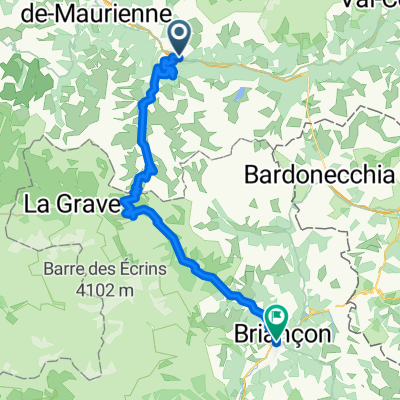
Der 4. Tag führt uns über den Col de Galibier nach Briancon.
- -:--
- Duration
- 72.6 km
- Distance
- 2,113 m
- Ascent
- 1,488 m
- Descent
- ---
- Avg. speed
- ---
- Max. altitude

Route quality
Waytypes & surfaces along the route
Waytypes
Quiet road
0.7 km
(1 %)
Path
0.7 km
(1 %)
Undefined
71.2 km
(98 %)
Surfaces
Paved
61 km
(84 %)
Asphalt
61 km
(84 %)
Undefined
11.6 km
(16 %)
Continue with Bikemap
Use, edit, or download this cycling route
You would like to ride Day 4: Route des Grandes Alpes by BY or customize it for your own trip? Here is what you can do with this Bikemap route:
Free features
- Save this route as favorite or in collections
- Copy & plan your own version of this route
- Sync your route with Garmin or Wahoo
Premium features
Free trial for 3 days, or one-time payment. More about Bikemap Premium.
- Navigate this route on iOS & Android
- Export a GPX / KML file of this route
- Create your custom printout (try it for free)
- Download this route for offline navigation
Discover more Premium features.
Get Bikemap PremiumFrom our community
Other popular routes starting in Saint-Michel-de-Maurienne
 COLL D´ ISERAN
- Distance
- 73.6 km
- Ascent
- 2,202 m
- Descent
- 153 m
- Location
- Saint-Michel-de-Maurienne, Auvergne-Rhône-Alpes, France
 G2N D3 Base Route
- Distance
- 71.6 km
- Ascent
- 2,026 m
- Descent
- 1,536 m
- Location
- Saint-Michel-de-Maurienne, Auvergne-Rhône-Alpes, France
 10 tappa traversata delle alpi
- Distance
- 75.7 km
- Ascent
- 2,092 m
- Descent
- 1,625 m
- Location
- Saint-Michel-de-Maurienne, Auvergne-Rhône-Alpes, France
 TELEGRAPHE - GALIBIER - BEAU PLAN
- Distance
- 94.3 km
- Ascent
- 2,870 m
- Descent
- 2,870 m
- Location
- Saint-Michel-de-Maurienne, Auvergne-Rhône-Alpes, France
 Alpentour 2008
- Distance
- 80.9 km
- Ascent
- 3,097 m
- Descent
- 3,082 m
- Location
- Saint-Michel-de-Maurienne, Auvergne-Rhône-Alpes, France
 CROIX DE FER
- Distance
- 63.9 km
- Ascent
- 2,571 m
- Descent
- 2,571 m
- Location
- Saint-Michel-de-Maurienne, Auvergne-Rhône-Alpes, France
 Telegraphe - Galibier
- Distance
- 64.7 km
- Ascent
- 2,218 m
- Descent
- 1,565 m
- Location
- Saint-Michel-de-Maurienne, Auvergne-Rhône-Alpes, France
 MONTVERNIER - TOUSSUIRE
- Distance
- 106.3 km
- Ascent
- 2,414 m
- Descent
- 2,414 m
- Location
- Saint-Michel-de-Maurienne, Auvergne-Rhône-Alpes, France
Open it in the app