

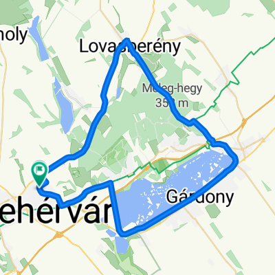
Csőszi-elág
A cycling route starting in Székesfehérvár, Fejér, Hungary.
Overview
About this route
- -:--
- Duration
- 19.9 km
- Distance
- 19 m
- Ascent
- 21 m
- Descent
- ---
- Avg. speed
- ---
- Max. altitude
Route quality
Waytypes & surfaces along the route
Waytypes
Quiet road
1 km
(5 %)
Path
0.8 km
(4 %)
Surfaces
Paved
18.1 km
(91 %)
Asphalt
18.1 km
(91 %)
Undefined
1.8 km
(9 %)
Continue with Bikemap
Use, edit, or download this cycling route
You would like to ride Csőszi-elág or customize it for your own trip? Here is what you can do with this Bikemap route:
Free features
- Save this route as favorite or in collections
- Copy & plan your own version of this route
- Sync your route with Garmin or Wahoo
Premium features
Free trial for 3 days, or one-time payment. More about Bikemap Premium.
- Navigate this route on iOS & Android
- Export a GPX / KML file of this route
- Create your custom printout (try it for free)
- Download this route for offline navigation
Discover more Premium features.
Get Bikemap PremiumFrom our community
Other popular routes starting in Székesfehérvár
 Fehervár-Dinnyés-Agárd-Gárdony-Velence-Sukoró-Pákozd-Fehervár
- Distance
- 45.3 km
- Ascent
- 148 m
- Descent
- 150 m
- Location
- Székesfehérvár, Fejér, Hungary
 Székesfehérvár Decathlon-Veszprém Decathlon
- Distance
- 52.8 km
- Ascent
- 330 m
- Descent
- 192 m
- Location
- Székesfehérvár, Fejér, Hungary
 Pakozd Ingokovek
- Distance
- 21.9 km
- Ascent
- 241 m
- Descent
- 240 m
- Location
- Székesfehérvár, Fejér, Hungary
 Csala Velencei-tó
- Distance
- 50.8 km
- Ascent
- 266 m
- Descent
- 267 m
- Location
- Székesfehérvár, Fejér, Hungary
 Szfvár(Sarló utca)-Velencei tó-Szfvár
- Distance
- 45.3 km
- Ascent
- 0 m
- Descent
- 0 m
- Location
- Székesfehérvár, Fejér, Hungary
 Székesfehérvár - Meleghegy
- Distance
- 47.9 km
- Ascent
- 416 m
- Descent
- 419 m
- Location
- Székesfehérvár, Fejér, Hungary
 Szfvár-Balatonakarattya (Rusty Coffee Box)
- Distance
- 67.8 km
- Ascent
- 366 m
- Descent
- 367 m
- Location
- Székesfehérvár, Fejér, Hungary
 Sékesfehérvár - Velencei tókör
- Distance
- 56.1 km
- Ascent
- 333 m
- Descent
- 335 m
- Location
- Székesfehérvár, Fejér, Hungary
Open it in the app