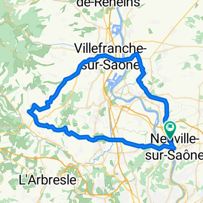
St Germain - Mont Thoux - St Didier
A cycling route starting in Genay, Auvergne-Rh么ne-Alpes, France.
Overview
About this route
Ca grimpe !<br />Mais la vue depuis le Mont Thoux sur Lyon est g茅niale !
- -:--
- Duration
- 16.5 km
- Distance
- 413 m
- Ascent
- 279 m
- Descent
- ---
- Avg. speed
- ---
- Avg. speed
Route quality
Waytypes & surfaces along the route
Waytypes
Busy road
8 km
(48 %)
Quiet road
4.4 km
(27 %)
Surfaces
Paved
7.8 km
(47 %)
Unpaved
1.4 km
(8 %)
Asphalt
7.8 km
(47 %)
Ground
1.4 km
(8 %)
Undefined
7.3 km
(44 %)
Continue with Bikemap
Use, edit, or download this cycling route
You would like to ride St Germain - Mont Thoux - St Didier or customize it for your own trip? Here is what you can do with this Bikemap route:
Free features
- Save this route as favorite or in collections
- Copy & plan your own version of this route
- Sync your route with Garmin or Wahoo
Premium features
Free trial for 3 days, or one-time payment. More about Bikemap Premium.
- Navigate this route on iOS & Android
- Export a GPX / KML file of this route
- Create your custom printout (try it for free)
- Download this route for offline navigation
Discover more Premium features.
Get Bikemap PremiumFrom our community
Other popular routes starting in Genay
- Neuville-oingt
- Distance
- 61.7 km
- Ascent
- 674 m
- Descent
- 675 m
- Location
- Genay, Auvergne-Rh么ne-Alpes, France
- Genay - Oingt
- Distance
- 61.2 km
- Ascent
- 734 m
- Descent
- 734 m
- Location
- Genay, Auvergne-Rh么ne-Alpes, France
- St Germain - Mont Thoux - St Didier
- Distance
- 16.5 km
- Ascent
- 413 m
- Descent
- 279 m
- Location
- Genay, Auvergne-Rh么ne-Alpes, France
- Genay to Horst
- Distance
- 806.3 km
- Ascent
- 4,421 m
- Descent
- 4,572 m
- Location
- Genay, Auvergne-Rh么ne-Alpes, France
- Saint Germain au Mont d'Or au Summet
- Distance
- 19.7 km
- Ascent
- 522 m
- Descent
- 522 m
- Location
- Genay, Auvergne-Rh么ne-Alpes, France
- Blistering ride in Genay
- Distance
- 47.9 km
- Ascent
- 803 m
- Descent
- 805 m
- Location
- Genay, Auvergne-Rh么ne-Alpes, France
- 2017.04.08-09 Monts du Lyonnais
- Distance
- 113.1 km
- Ascent
- 1,186 m
- Descent
- 1,198 m
- Location
- Genay, Auvergne-Rh么ne-Alpes, France
- Sporty route in Genay
- Distance
- 38.3 km
- Ascent
- 645 m
- Descent
- 643 m
- Location
- Genay, Auvergne-Rh么ne-Alpes, France
Open it in the app