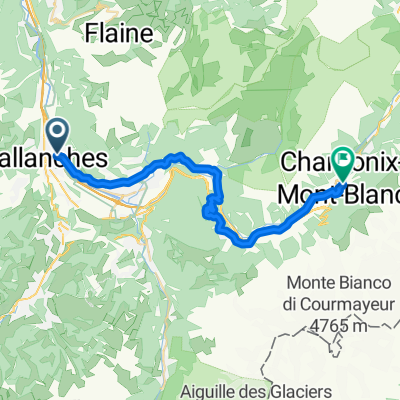
Les Houches School; round 1
A cycling route starting in Sallanches, Auvergne-Rh么ne-Alpes, France.
Overview
About this route
- -:--
- Duration
- 94.6 km
- Distance
- 2,000 m
- Ascent
- 1,534 m
- Descent
- ---
- Avg. speed
- 1,618 m
- Max. altitude
Route quality
Waytypes & surfaces along the route
Waytypes
Quiet road
11.3 km
(12 %)
Access road
4.7 km
(5 %)
Surfaces
Paved
63.4 km
(67 %)
Unpaved
1.9 km
(2 %)
Asphalt
62.4 km
(66 %)
Paved (undefined)
0.9 km
(1 %)
Continue with Bikemap
Use, edit, or download this cycling route
You would like to ride Les Houches School; round 1 or customize it for your own trip? Here is what you can do with this Bikemap route:
Free features
- Save this route as favorite or in collections
- Copy & plan your own version of this route
- Split it into stages to create a multi-day tour
- Sync your route with Garmin or Wahoo
Premium features
Free trial for 3 days, or one-time payment. More about Bikemap Premium.
- Navigate this route on iOS & Android
- Export a GPX / KML file of this route
- Create your custom printout (try it for free)
- Download this route for offline navigation
Discover more Premium features.
Get Bikemap PremiumFrom our community
Other popular routes starting in Sallanches
- 4. Sallanches-Albertville (2)
- Distance
- 92.1 km
- Ascent
- 1,932 m
- Descent
- 2,152 m
- Location
- Sallanches, Auvergne-Rh么ne-Alpes, France
- TIME 2011 corto
- Distance
- 81.8 km
- Ascent
- 1,895 m
- Descent
- 1,327 m
- Location
- Sallanches, Auvergne-Rh么ne-Alpes, France
- Les Houches School; round 1
- Distance
- 94.6 km
- Ascent
- 2,000 m
- Descent
- 1,534 m
- Location
- Sallanches, Auvergne-Rh么ne-Alpes, France
- Tour de France 2016 - Stage 18
- Distance
- 17 km
- Ascent
- 674 m
- Descent
- 130 m
- Location
- Sallanches, Auvergne-Rh么ne-Alpes, France
- 2017 ALPS Etapa 6 - Avoiraz - la joux-plane
- Distance
- 127.3 km
- Ascent
- 2,346 m
- Descent
- 2,348 m
- Location
- Sallanches, Auvergne-Rh么ne-Alpes, France
- 2017 ALPS Etapa 5 - La Colombi猫re
- Distance
- 99 km
- Ascent
- 2,203 m
- Descent
- 2,203 m
- Location
- Sallanches, Auvergne-Rh么ne-Alpes, France
- Route d'O毛x, Sallanches nach Chemin de la Violette, Cointrin
- Distance
- 63 km
- Ascent
- 212 m
- Descent
- 310 m
- Location
- Sallanches, Auvergne-Rh么ne-Alpes, France
- Mont d'arbois
- Distance
- 53.9 km
- Ascent
- 1,529 m
- Descent
- 1,529 m
- Location
- Sallanches, Auvergne-Rh么ne-Alpes, France
Open it in the app