
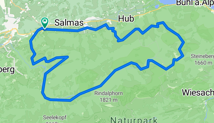
Um den Prodel herum
A cycling route starting in Oberstaufen, Bavaria, Germany.
Overview
About this route
Schöner Rundweg mit teilweise lange Anstiege. Startpunkt ist der Hündle-Parkplatz und dann Richtung Buchenegg, Hochgratbahn und die Strasse weiter folgend.
Hierbei unbedingt an der Unteregg-Alpe die leichtere Variante gerade aus wählen, mündet in einem Trail. Später zweigt man zum "Naturfreundehaus" und wieder zurück oberhalb der Hauptstrasse. - -:--
- Duration
- 36 km
- Distance
- 1,189 m
- Ascent
- 1,166 m
- Descent
- ---
- Avg. speed
- 1,424 m
- Max. altitude
Route quality
Waytypes & surfaces along the route
Waytypes
Track
21.9 km
(61 %)
Access road
6.5 km
(18 %)
Surfaces
Paved
22.3 km
(62 %)
Unpaved
12.6 km
(35 %)
Asphalt
21.9 km
(61 %)
Gravel
7.2 km
(20 %)
Continue with Bikemap
Use, edit, or download this cycling route
You would like to ride Um den Prodel herum or customize it for your own trip? Here is what you can do with this Bikemap route:
Free features
- Save this route as favorite or in collections
- Copy & plan your own version of this route
- Sync your route with Garmin or Wahoo
Premium features
Free trial for 3 days, or one-time payment. More about Bikemap Premium.
- Navigate this route on iOS & Android
- Export a GPX / KML file of this route
- Create your custom printout (try it for free)
- Download this route for offline navigation
Discover more Premium features.
Get Bikemap PremiumFrom our community
Other popular routes starting in Oberstaufen
 10. Oberstaufen-Kriessern-80km-500Hm
- Distance
- 80.8 km
- Ascent
- 527 m
- Descent
- 911 m
- Location
- Oberstaufen, Bavaria, Germany
 Oberstaufen-Rohrmoss-Oberstaufen
- Distance
- 82.4 km
- Ascent
- 823 m
- Descent
- 823 m
- Location
- Oberstaufen, Bavaria, Germany
 Rund um den Alpsee - Biketour 42 km-900 hm
- Distance
- 42.1 km
- Ascent
- 960 m
- Descent
- 960 m
- Location
- Oberstaufen, Bavaria, Germany
 Hündle_Alpsee
- Distance
- 19.3 km
- Ascent
- 667 m
- Descent
- 689 m
- Location
- Oberstaufen, Bavaria, Germany
 Oberstaufen -Gardasee 2013
- Distance
- 397.7 km
- Ascent
- 4,038 m
- Descent
- 4,762 m
- Location
- Oberstaufen, Bavaria, Germany
 Kleine Grenzrunde
- Distance
- 35.5 km
- Ascent
- 516 m
- Descent
- 516 m
- Location
- Oberstaufen, Bavaria, Germany
 Alpsee-Panorama
- Distance
- 35.1 km
- Ascent
- 597 m
- Descent
- 597 m
- Location
- Oberstaufen, Bavaria, Germany
 Übers Hündle
- Distance
- 10.8 km
- Ascent
- 408 m
- Descent
- 411 m
- Location
- Oberstaufen, Bavaria, Germany
Open it in the app