

Haytor Megaavalanche
A cycling route starting in Bovey Tracey, England, United Kingdom.
Overview
About this route
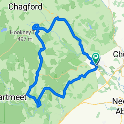
Car 1 - Haytor track - Smallacombe rocks track - Houndtor - Jays grave - Hammeldown - Widecombe - car 2
- -:--
- Duration
- 13.3 km
- Distance
- 318 m
- Ascent
- 498 m
- Descent
- ---
- Avg. speed
- ---
- Max. altitude
Continue with Bikemap
Use, edit, or download this cycling route
You would like to ride Haytor Megaavalanche or customize it for your own trip? Here is what you can do with this Bikemap route:
Free features
- Save this route as favorite or in collections
- Copy & plan your own version of this route
- Sync your route with Garmin or Wahoo
Premium features
Free trial for 3 days, or one-time payment. More about Bikemap Premium.
- Navigate this route on iOS & Android
- Export a GPX / KML file of this route
- Create your custom printout (try it for free)
- Download this route for offline navigation
Discover more Premium features.
Get Bikemap PremiumFrom our community
Other popular routes starting in Bovey Tracey
 Station Road 6A to Station Road 6A
- Distance
- 51.2 km
- Ascent
- 1,105 m
- Descent
- 1,103 m
- Location
- Bovey Tracey, England, United Kingdom
 Day 12, 67 miles from Moretonhamstead to Carlyon Bay
- Distance
- 106.9 km
- Ascent
- 1,707 m
- Descent
- 1,848 m
- Location
- Bovey Tracey, England, United Kingdom
 Day 3
Day 3- Distance
- 112.6 km
- Ascent
- 1,335 m
- Descent
- 1,489 m
- Location
- Bovey Tracey, England, United Kingdom
 Pound Street 36, Moretonhampstead to Primrose Drive 46
- Distance
- 23.8 km
- Ascent
- 90 m
- Descent
- 244 m
- Location
- Bovey Tracey, England, United Kingdom
 Wray Valley Trail
- Distance
- 11.4 km
- Ascent
- 214 m
- Descent
- 35 m
- Location
- Bovey Tracey, England, United Kingdom
 Dartmoor
- Distance
- 31.1 km
- Ascent
- 580 m
- Descent
- 580 m
- Location
- Bovey Tracey, England, United Kingdom
 Haytor Megaavalanche
- Distance
- 13.3 km
- Ascent
- 318 m
- Descent
- 498 m
- Location
- Bovey Tracey, England, United Kingdom
 POSSIBLE 2ND DARTMOOR (START BOVEY TRACEY)
- Distance
- 55.3 km
- Ascent
- 805 m
- Descent
- 806 m
- Location
- Bovey Tracey, England, United Kingdom
Open it in the app