Sandy to Lolo Pass
A cycling route starting in Sandy, Oregon, United States.
Overview
About this route
Beautiful scenery, very little traffic, and excellent climbs. Good as an out and back.
- -:--
- Duration
- 47.7 km
- Distance
- 1,039 m
- Ascent
- 604 m
- Descent
- ---
- Avg. speed
- 732 m
- Max. altitude
Route quality
Waytypes & surfaces along the route
Waytypes
Road
36.3 km
(76 %)
Quiet road
3.3 km
(7 %)
Surfaces
Paved
28.1 km
(59 %)
Unpaved
1.9 km
(4 %)
Paved (undefined)
15.7 km
(33 %)
Asphalt
12.4 km
(26 %)
Continue with Bikemap
Use, edit, or download this cycling route
You would like to ride Sandy to Lolo Pass or customize it for your own trip? Here is what you can do with this Bikemap route:
Free features
- Save this route as favorite or in collections
- Copy & plan your own version of this route
- Sync your route with Garmin or Wahoo
Premium features
Free trial for 3 days, or one-time payment. More about Bikemap Premium.
- Navigate this route on iOS & Android
- Export a GPX / KML file of this route
- Create your custom printout (try it for free)
- Download this route for offline navigation
Discover more Premium features.
Get Bikemap PremiumFrom our community
Other popular routes starting in Sandy
- Sandy to Lolo Pass
- Distance
- 47.7 km
- Ascent
- 1,039 m
- Descent
- 604 m
- Location
- Sandy, Oregon, United States
- 4/3 short ride through Sandy
- Distance
- 6.2 km
- Ascent
- 101 m
- Descent
- 102 m
- Location
- Sandy, Oregon, United States
- 39250 Pioneer Blvd, Sandy to Salmon River National Recreation Trail, Government Camp
- Distance
- 65.8 km
- Ascent
- 1,340 m
- Descent
- 740 m
- Location
- Sandy, Oregon, United States
- 39250 Pioneer Blvd, Sandy to 27500 E Timberline Rd, Rhododendron
- Distance
- 64.1 km
- Ascent
- 2,256 m
- Descent
- 742 m
- Location
- Sandy, Oregon, United States
- 40311 Therese St, Sandy a 20060 SE Highway 212, Damascus
- Distance
- 19 km
- Ascent
- 77 m
- Descent
- 237 m
- Location
- Sandy, Oregon, United States
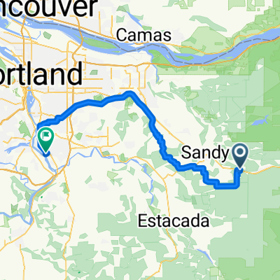
- Sandy to SE Naef Rd, Portland
- Distance
- 62.3 km
- Ascent
- 538 m
- Descent
- 883 m
- Location
- Sandy, Oregon, United States
- 10770 SE 362nd Ave, Boring to 2849 SE 70th Ave, Portland
- Distance
- 27.8 km
- Ascent
- 77 m
- Descent
- 229 m
- Location
- Sandy, Oregon, United States
- trial
- Distance
- 27.9 km
- Ascent
- 323 m
- Descent
- 373 m
- Location
- Sandy, Oregon, United States
Open it in the app