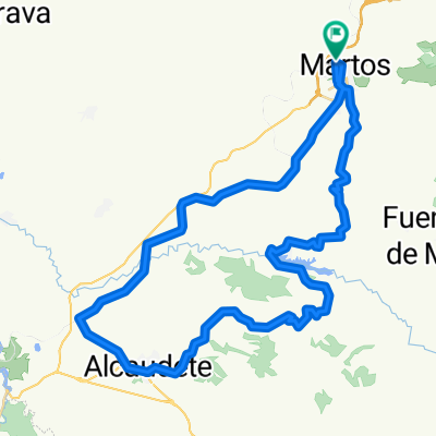
Venta el papero,Fuente el espino,presa Viboras,Martos
- 43.8 km
- 894 m
- 873 m
- Martos, Andalusia, Spain
A cycling route starting in Martos, Andalusia, Spain.
Overview
The itinerary was as follows: we headed towards Fuensanta, passing the gas station, we turned left towards Las Veletas and Venta El Papero. We crossed the bridge over the river and the suffering began, the incline increased, we passed through Los Llanillos, Fuente El Espino and continued climbing. We headed towards Hoyo Piedra which already belongs to Castillo de Locubín but without reaching it, we turned right before on a descending local road that leads us to the hermitage of Villarbajo. Once there we continued descending to the dam of Viboras, from there we headed towards Martos by the Velda and Romeral path.
This route passes through rural areas where everything the land offers is still utilized: figs, quinces, mushrooms, asparagus, acorns, walnuts, almonds, etc. depending on the season we will see locals preparing various products.
created this 13 years ago
Route quality
Road
21.5 km
(49 %)
Track
12.7 km
(29 %)
Paved
11.4 km
(26 %)
Unpaved
2.6 km
(6 %)
Asphalt
11.4 km
(26 %)
Ground
2.6 km
(6 %)
Undefined
29.8 km
(68 %)
Continue with Bikemap
You would like to ride Venta el papero,Fuente el espino,presa Viboras,Martos or customize it for your own trip? Here is what you can do with this Bikemap route:
Free trial for 3 days, or one-time payment. More about Bikemap Premium.
Discover more Premium features.
Get Bikemap PremiumFrom our community
Open it in the app