

St Wilfrid's Way- Byrness to Jedburgh
A cycling route starting in Rochester, England, United Kingdom.
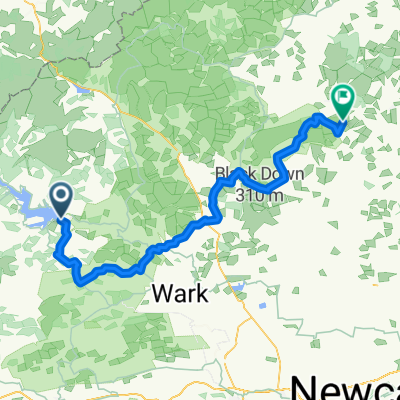
Overview
About this route
From Byrness proceed north along Pennine Way, then follow the Roman road, Dere Sreet, for about 19km until it crosses St Cuthbert's Way. Take left track following the way to Jedburgh.
This is the 4th section and longest of the great pilgrim trail, St Wilfrid’s Way, from Hexham to Edinburgh and then on to St Andrews (website:http://www.thewayofstandrews.com/)
- -:--
- Duration
- 32.3 km
- Distance
- 570 m
- Ascent
- 721 m
- Descent
- ---
- Avg. speed
- ---
- Max. altitude

Route highlights
Points of interest along the route
Point of interest after 0.5 km
Pennine Way
Continue with Bikemap
Use, edit, or download this cycling route
You would like to ride St Wilfrid's Way- Byrness to Jedburgh or customize it for your own trip? Here is what you can do with this Bikemap route:
Free features
- Save this route as favorite or in collections
- Copy & plan your own version of this route
- Sync your route with Garmin or Wahoo
Premium features
Free trial for 3 days, or one-time payment. More about Bikemap Premium.
- Navigate this route on iOS & Android
- Export a GPX / KML file of this route
- Create your custom printout (try it for free)
- Download this route for offline navigation
Discover more Premium features.
Get Bikemap PremiumFrom our community
Other popular routes starting in Rochester
 Tour de Wielka Brytania & Irlandia 2019 dzień 17
- Distance
- 143.7 km
- Ascent
- 1,118 m
- Descent
- 1,248 m
- Location
- Rochester, England, United Kingdom
 Kielder Water
- Distance
- 48.4 km
- Ascent
- 444 m
- Descent
- 444 m
- Location
- Rochester, England, United Kingdom
 Periple 11 / 28
- Distance
- 167.7 km
- Ascent
- 1,250 m
- Descent
- 1,182 m
- Location
- Rochester, England, United Kingdom
 Rochester Radfahren
- Distance
- 39.8 km
- Ascent
- 514 m
- Descent
- 512 m
- Location
- Rochester, England, United Kingdom
 Pt9 THE FINAL DAY
- Distance
- 93.5 km
- Ascent
- 509 m
- Descent
- 675 m
- Location
- Rochester, England, United Kingdom
 Tarmac alternative (NCN68) missing off road/ crossing fields at Clennell.
- Distance
- 3.9 km
- Ascent
- 106 m
- Descent
- 10 m
- Location
- Rochester, England, United Kingdom
 LEJOG - Day 10
- Distance
- 112.6 km
- Ascent
- 921 m
- Descent
- 1,112 m
- Location
- Rochester, England, United Kingdom
 Rochester - Rothbury
- Distance
- 67.3 km
- Ascent
- 838 m
- Descent
- 869 m
- Location
- Rochester, England, United Kingdom
Open it in the app