

Aurillac - Puy de Dôme
A cycling route starting in Orcines, Auvergne-Rhône-Alpes, France.
Overview
About this route
- -:--
- Duration
- 192 km
- Distance
- 2,575 m
- Ascent
- 3,402 m
- Descent
- ---
- Avg. speed
- ---
- Max. altitude

Route highlights
Points of interest along the route
Point of interest after 4.2 km
Puy de Dôme 1465 m
Point of interest after 54 km
Col de la Croix-Morand 1401 m
Point of interest after 136.4 km
Col d'Aulac
Point of interest after 152.5 km
Pas de Peyrol 1589 m
Continue with Bikemap
Use, edit, or download this cycling route
You would like to ride Aurillac - Puy de Dôme or customize it for your own trip? Here is what you can do with this Bikemap route:
Free features
- Save this route as favorite or in collections
- Copy & plan your own version of this route
- Split it into stages to create a multi-day tour
- Sync your route with Garmin or Wahoo
Premium features
Free trial for 3 days, or one-time payment. More about Bikemap Premium.
- Navigate this route on iOS & Android
- Export a GPX / KML file of this route
- Create your custom printout (try it for free)
- Download this route for offline navigation
Discover more Premium features.
Get Bikemap PremiumFrom our community
Other popular routes starting in Orcines
 Aurillac - Puy de Dôme
- Distance
- 192 km
- Ascent
- 2,575 m
- Descent
- 3,402 m
- Location
- Orcines, Auvergne-Rhône-Alpes, France
 chopine 19km 430d+
- Distance
- 18.9 km
- Ascent
- 424 m
- Descent
- 424 m
- Location
- Orcines, Auvergne-Rhône-Alpes, France
 Route des Vulcans
- Distance
- 53.3 km
- Ascent
- 587 m
- Descent
- 610 m
- Location
- Orcines, Auvergne-Rhône-Alpes, France
 FDL Massif Centrale
- Distance
- 66 km
- Ascent
- 1,565 m
- Descent
- 1,506 m
- Location
- Orcines, Auvergne-Rhône-Alpes, France
 France Ultime : Villefranche-sur-Saône - Puy de Dôme
- Distance
- 182.3 km
- Ascent
- 1,348 m
- Descent
- 2,577 m
- Location
- Orcines, Auvergne-Rhône-Alpes, France
 Grande traversee du massif central
- Distance
- 476.3 km
- Ascent
- 4,480 m
- Descent
- 5,394 m
- Location
- Orcines, Auvergne-Rhône-Alpes, France
 Mâcon - Puy de Dôme
- Distance
- 232.8 km
- Ascent
- 2,066 m
- Descent
- 3,304 m
- Location
- Orcines, Auvergne-Rhône-Alpes, France
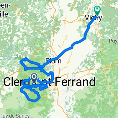 Vichy - Puy de Dôme
- Distance
- 193.4 km
- Ascent
- 1,841 m
- Descent
- 3,025 m
- Location
- Orcines, Auvergne-Rhône-Alpes, France
Open it in the app