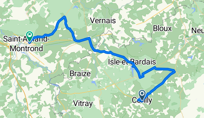
Tour de france 2008, Etappe 20, Cérilly- Saint- Amand- Montrond, Fabian Suhr
A cycling route starting in Cérilly, Auvergne-Rhône-Alpes, France.
Overview
About this route
Tour de france 2008, Etappe 20, Cérilly- Saint- Amand- Montrond, Fabian Suhr
- -:--
- Duration
- 53.5 km
- Distance
- 321 m
- Ascent
- 423 m
- Descent
- ---
- Avg. speed
- 331 m
- Avg. speed
Route quality
Waytypes & surfaces along the route
Waytypes
Busy road
25 km
(47 %)
Road
17.7 km
(33 %)
Surfaces
Paved
1.2 km
(2 %)
Asphalt
1.2 km
(2 %)
Undefined
52.3 km
(98 %)
Continue with Bikemap
Use, edit, or download this cycling route
You would like to ride Tour de france 2008, Etappe 20, Cérilly- Saint- Amand- Montrond, Fabian Suhr or customize it for your own trip? Here is what you can do with this Bikemap route:
Free features
- Save this route as favorite or in collections
- Copy & plan your own version of this route
- Sync your route with Garmin or Wahoo
Premium features
Free trial for 3 days, or one-time payment. More about Bikemap Premium.
- Navigate this route on iOS & Android
- Export a GPX / KML file of this route
- Create your custom printout (try it for free)
- Download this route for offline navigation
Discover more Premium features.
Get Bikemap PremiumFrom our community
Other popular routes starting in Cérilly
- Tour de france 2008, Etappe 20, Cérilly- Saint- Amand- Montrond, Fabian Suhr
- Distance
- 53.5 km
- Ascent
- 321 m
- Descent
- 423 m
- Location
- Cérilly, Auvergne-Rhône-Alpes, France
- De Les Emprunts 2, Saint-Plaisir à D534, Saint-Plaisir
- Distance
- 43.1 km
- Ascent
- 507 m
- Descent
- 514 m
- Location
- Cérilly, Auvergne-Rhône-Alpes, France
- Tour69-Rit4.5
- Distance
- 132.9 km
- Ascent
- 438 m
- Descent
- 588 m
- Location
- Cérilly, Auvergne-Rhône-Alpes, France
- Rondje hartje
- Distance
- 45.3 km
- Ascent
- 437 m
- Descent
- 445 m
- Location
- Cérilly, Auvergne-Rhône-Alpes, France
- Cérilly 1
- Distance
- 76.2 km
- Ascent
- 577 m
- Descent
- 574 m
- Location
- Cérilly, Auvergne-Rhône-Alpes, France
- 19 јули
- Distance
- 140.3 km
- Ascent
- 297 m
- Descent
- 528 m
- Location
- Cérilly, Auvergne-Rhône-Alpes, France
- de Cérilly a val d'Epy
- Distance
- 259 km
- Ascent
- 797 m
- Descent
- 734 m
- Location
- Cérilly, Auvergne-Rhône-Alpes, France
- Cérilly-Pontaubert
- Distance
- 150 km
- Ascent
- 728 m
- Descent
- 882 m
- Location
- Cérilly, Auvergne-Rhône-Alpes, France
Open it in the app