

Bibersohl-Tauchenweiler_GPS
A cycling route starting in Heidenheim, Baden-Wurttemberg, Germany.
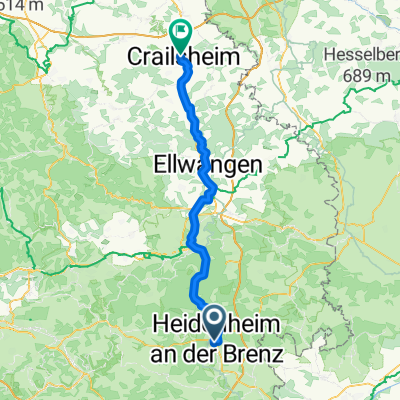
Overview
About this route
Short MTB training round, Bibersohl instead of Wental, thus suitable for the holiday.
- -:--
- Duration
- 36.3 km
- Distance
- 348 m
- Ascent
- 346 m
- Descent
- ---
- Avg. speed
- ---
- Max. altitude
Continue with Bikemap
Use, edit, or download this cycling route
You would like to ride Bibersohl-Tauchenweiler_GPS or customize it for your own trip? Here is what you can do with this Bikemap route:
Free features
- Save this route as favorite or in collections
- Copy & plan your own version of this route
- Sync your route with Garmin or Wahoo
Premium features
Free trial for 3 days, or one-time payment. More about Bikemap Premium.
- Navigate this route on iOS & Android
- Export a GPX / KML file of this route
- Create your custom printout (try it for free)
- Download this route for offline navigation
Discover more Premium features.
Get Bikemap PremiumFrom our community
Other popular routes starting in Heidenheim
 STTour Heidenheim BikePark
- Distance
- 7.9 km
- Ascent
- 312 m
- Descent
- 311 m
- Location
- Heidenheim, Baden-Wurttemberg, Germany
 Meine große Trainingsstrecke
- Distance
- 51.1 km
- Ascent
- 556 m
- Descent
- 547 m
- Location
- Heidenheim, Baden-Wurttemberg, Germany
 Crailsheim nach Schloß Hellenstein
- Distance
- 72.5 km
- Ascent
- 534 m
- Descent
- 676 m
- Location
- Heidenheim, Baden-Wurttemberg, Germany
 Oberer Erbisberg 27, Heidenheim an der Brenz nach Oberer Erbisberg 23, Heidenheim an der Brenz
- Distance
- 14.3 km
- Ascent
- 93 m
- Descent
- 94 m
- Location
- Heidenheim, Baden-Wurttemberg, Germany
 Eselsburger Tal
- Distance
- 25.1 km
- Ascent
- 124 m
- Descent
- 124 m
- Location
- Heidenheim, Baden-Wurttemberg, Germany
 MTB Volkmarsbergtour
- Distance
- 39.3 km
- Ascent
- 548 m
- Descent
- 551 m
- Location
- Heidenheim, Baden-Wurttemberg, Germany
 Auernheimrunde_GPS
- Distance
- 39.1 km
- Ascent
- 661 m
- Descent
- 629 m
- Location
- Heidenheim, Baden-Wurttemberg, Germany
 Alb aktiv Heidenheim Ostalb
- Distance
- 46.4 km
- Ascent
- 537 m
- Descent
- 535 m
- Location
- Heidenheim, Baden-Wurttemberg, Germany
Open it in the app