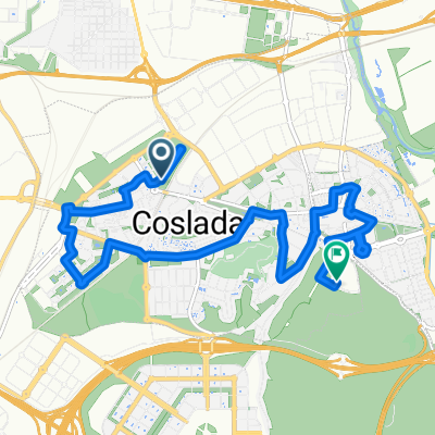
Marcha en bici por un Hospital del Henares público y de calidad.
- 12.2 km
- 120 m
- 116 m
- Coslada, Madrid, Spain
A cycling route starting in Coslada, Madrid, Spain.
Overview
Also for cyclists, a public, nearby, and quality hospital is necessary. Coslada on Bike cannot feel indifferent to the mobilizations in defense of Public Health. That's why on December 6, 2012, we will leave from the Coslada Exhibition Center, touring all health centers in Coslada and San Fernando, ending at the Hospital del Henares.
created this 13 years ago
Route quality
Quiet road
6.1 km
(50 %)
Road
3.3 km
(27 %)
Paved
6.7 km
(55 %)
Asphalt
6.4 km
(53 %)
Paved (undefined)
0.2 km
(2 %)
Undefined
5.5 km
(45 %)
Route highlights
Salimos a las 12:00 del recinto ferial de Coslada. Una pequeña vuelta por el ferial para saludarnos y poner en marcha la caravana.
1ª parada: Centro de Salud Doctor Tamames
Ayuntamiento de Coslada
Centro de Salud Barrio del Puerto
Centro de Salud Jaime Vera
Centro de Salud Valleaguado
Centro de Salud Ciudad San Pablo
Centro de Salud Alperchines
Centro de Salud San Fernando II
Continue with Bikemap
You would like to ride Marcha en bici por un Hospital del Henares público y de calidad. or customize it for your own trip? Here is what you can do with this Bikemap route:
Free trial for 3 days, or one-time payment. More about Bikemap Premium.
Discover more Premium features.
Get Bikemap PremiumFrom our community
Open it in the app