opfinger sonnenbergschleife
- 6.6 km
- 70 m
- 70 m
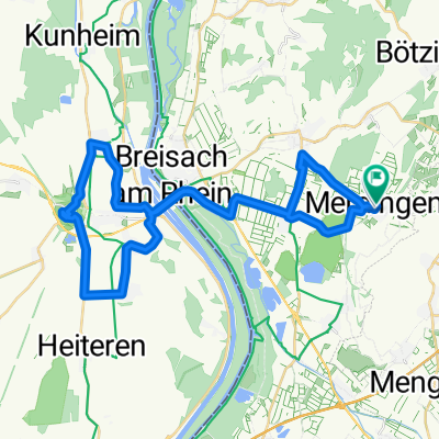
- Merdingen, Baden-Wurttemberg, Germany
A cycling route starting in Merdingen, Baden-Wurttemberg, Germany.
Overview
flat roll-in to Buggingen, then comes the darkness, first ascent about 2km long. After that, it's very nice and hilly through the Markgräfler Land with a view of the Rhine valley. After Johannisbreite, the first descent to Kandern follows. At the exit of Kandern, we turn right towards the bird park. There follows a nice moderate climb in the forest. The next descent takes us to Kleine Wiesental, until Wieslet. Now we steadily climb about 15 km up the Wiesental to Neuenweg. Here we turn left and after another 5 km of climbing, we are at the highest point of our tour. The subsequent descent through Münsterhalden into the Münstertal is scenic, but to be enjoyed with caution due to the poor road conditions. From Münstertal, we roll back home easily.
created this 16 years ago
Route quality
Road
41.4 km
(45 %)
Quiet road
6.4 km
(7 %)
Paved
76.4 km
(83 %)
Unpaved
0.9 km
(1 %)
Asphalt
75.5 km
(82 %)
Concrete
0.9 km
(1 %)
Continue with Bikemap
You would like to ride Kleines Wiesental am Blauen vorbei or customize it for your own trip? Here is what you can do with this Bikemap route:
Free trial for 3 days, or one-time payment. More about Bikemap Premium.
Discover more Premium features.
Get Bikemap PremiumFrom our community
Open it in the app