
Vor(Eifel) 198 / K-MON-K
A cycling route starting in Nippes, North Rhine-Westphalia, Germany.
Overview
About this route
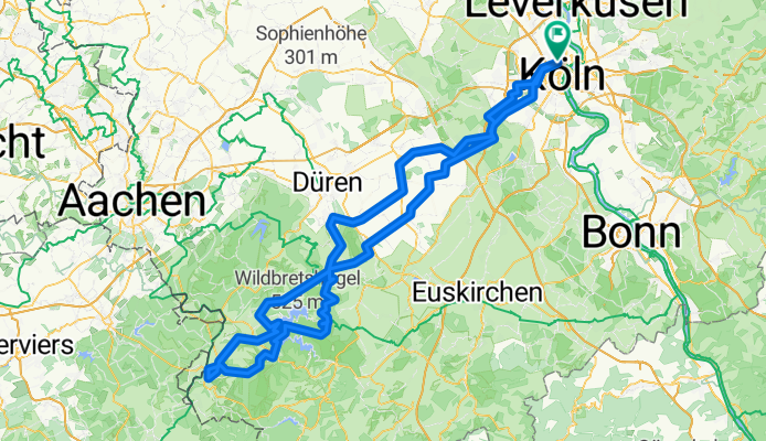
Größtenteils über Nebenstrecken raus aus Köln bis zum Eifelrand bei Nideggen. Von dort weiter nach Heimbach und 1. ernstzunehmende Bergwertung rauf zur Abtei Mariawald. Vom Haus Kermeter über den betonierten Waldlehrpfad und 9 Spitzkehren runter zum Rurseeufer (nur im Sommer bei trockenem Wetter mit dem Rennrad befahrbar). Dann 900 m feste Schotterpiste zum Paulusdamm, dann weiter am Obersee entlang nach Dedenborn. Nach Überquerung der Rur beginnt die 2. Bergwertung mit dem steilen Anstieg rauf nach Hammer und weiter nach Imgenbroich. Dann über die B258 nach Monschau, wo die Hälfte der Strecke geschafft ist.
Nach kurzer Kaffeepause geht's zurück nach Imgenbroich und dahinter rechts weg nach Simmerath. Von dort kann man entweder den direkten Weg nach Strauch nehmen oder ein paar weitere Kilometer und Höhenmeter sammeln, um die rasante Abfahrt runter nach Rurberg und anschließend bei Woffelsbach die 3. steile Bergwertung rauf nach Steckenborn zu nehmen. Von dort führt der Weg über die vielbefahrene L246 über Schmidt zurück nach Nideggen. Von dort nehmen wir eine Parallelroute, teils über Hauptstraßen, teils über Feldwege, zurück nach Köln.
- -:--
- Duration
- 197.5 km
- Distance
- 2,479 m
- Ascent
- 2,429 m
- Descent
- ---
- Avg. speed
- 559 m
- Max. altitude
Route quality
Waytypes & surfaces along the route
Waytypes
Busy road
73.3 km
(37 %)
Road
41 km
(21 %)
Surfaces
Paved
130.9 km
(66 %)
Unpaved
20.4 km
(10 %)
Asphalt
118.7 km
(60 %)
Gravel
17.3 km
(9 %)
Route highlights
Points of interest along the route
Point of interest after 54.9 km
Tankstelle
Point of interest after 104.7 km
Tankstelle
Point of interest after 162.1 km
Tankstelle
Continue with Bikemap
Use, edit, or download this cycling route
You would like to ride Vor(Eifel) 198 / K-MON-K or customize it for your own trip? Here is what you can do with this Bikemap route:
Free features
- Save this route as favorite or in collections
- Copy & plan your own version of this route
- Split it into stages to create a multi-day tour
- Sync your route with Garmin or Wahoo
Premium features
Free trial for 3 days, or one-time payment. More about Bikemap Premium.
- Navigate this route on iOS & Android
- Export a GPX / KML file of this route
- Create your custom printout (try it for free)
- Download this route for offline navigation
Discover more Premium features.
Get Bikemap PremiumFrom our community
Other popular routes starting in Nippes
 Bergisches + Flughafen = 100km, 1000hm
- Distance
- 104.9 km
- Ascent
- 763 m
- Descent
- 765 m
- Location
- Nippes, North Rhine-Westphalia, Germany
 thursday
- Distance
- 4.8 km
- Ascent
- 15 m
- Descent
- 12 m
- Location
- Nippes, North Rhine-Westphalia, Germany
 Trassenparty und Kürtener Achterbahn
- Distance
- 126.3 km
- Ascent
- 1,599 m
- Descent
- 1,599 m
- Location
- Nippes, North Rhine-Westphalia, Germany
 Route ins Bergische
- Distance
- 76.4 km
- Ascent
- 600 m
- Descent
- 599 m
- Location
- Nippes, North Rhine-Westphalia, Germany
 Bergisches 75
- Distance
- 74.9 km
- Ascent
- 754 m
- Descent
- 701 m
- Location
- Nippes, North Rhine-Westphalia, Germany
 Köln - Terra Nova - Köln
- Distance
- 81 km
- Ascent
- 207 m
- Descent
- 208 m
- Location
- Nippes, North Rhine-Westphalia, Germany
 testfa
- Distance
- 57.6 km
- Ascent
- 64 m
- Descent
- 69 m
- Location
- Nippes, North Rhine-Westphalia, Germany
 Trainingsrunde Köln-Voiswinkel-Köln
- Distance
- 41 km
- Ascent
- 241 m
- Descent
- 243 m
- Location
- Nippes, North Rhine-Westphalia, Germany
Open it in the app