

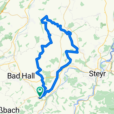
Von Laichberger nach St. Nikola über Ramsau
A cycling route starting in Waldneukirchen, Upper Austria, Austria.
Overview
About this route
- -:--
- Duration
- 48.4 km
- Distance
- 740 m
- Ascent
- 739 m
- Descent
- ---
- Avg. speed
- 537 m
- Max. altitude
Route quality
Waytypes & surfaces along the route
Waytypes
Quiet road
18.4 km
(38 %)
Cycleway
15.5 km
(32 %)
Surfaces
Paved
22.3 km
(46 %)
Asphalt
19.4 km
(40 %)
Paved (undefined)
2.9 km
(6 %)
Undefined
26.1 km
(54 %)
Continue with Bikemap
Use, edit, or download this cycling route
You would like to ride Von Laichberger nach St. Nikola über Ramsau or customize it for your own trip? Here is what you can do with this Bikemap route:
Free features
- Save this route as favorite or in collections
- Copy & plan your own version of this route
- Sync your route with Garmin or Wahoo
Premium features
Free trial for 3 days, or one-time payment. More about Bikemap Premium.
- Navigate this route on iOS & Android
- Export a GPX / KML file of this route
- Create your custom printout (try it for free)
- Download this route for offline navigation
Discover more Premium features.
Get Bikemap PremiumFrom our community
Other popular routes starting in Waldneukirchen
 2025_10_15_Überlandpartie-West
- Distance
- 52.8 km
- Ascent
- 459 m
- Descent
- 457 m
- Location
- Waldneukirchen, Upper Austria, Austria
 2023_10_21_Bad Haller-Tassilorunde
- Distance
- 52.8 km
- Ascent
- 616 m
- Descent
- 616 m
- Location
- Waldneukirchen, Upper Austria, Austria
 Von Laichberger nach St. Nikola über Ramsau
- Distance
- 48.4 km
- Ascent
- 740 m
- Descent
- 739 m
- Location
- Waldneukirchen, Upper Austria, Austria
 Etappe9
- Distance
- 21.6 km
- Ascent
- 159 m
- Descent
- 266 m
- Location
- Waldneukirchen, Upper Austria, Austria
 Waldneukirchen - Bad Hall (Ortszentren, Umgehung von Hauptverkehrsstraßen)
- Distance
- 6.2 km
- Ascent
- 28 m
- Descent
- 89 m
- Location
- Waldneukirchen, Upper Austria, Austria
 Waldneukirchen - Untergrünburg (Ortszentren, Umgehung von Hauptverkehrsstraßen)
- Distance
- 4.3 km
- Ascent
- 26 m
- Descent
- 105 m
- Location
- Waldneukirchen, Upper Austria, Austria
 2023_11_04_Bad Haller-Auf´s Weiss´n
- Distance
- 44 km
- Ascent
- 742 m
- Descent
- 741 m
- Location
- Waldneukirchen, Upper Austria, Austria
 Grünburg Trattenbach Grünburgerhütte
- Distance
- 55.9 km
- Ascent
- 1,536 m
- Descent
- 1,536 m
- Location
- Waldneukirchen, Upper Austria, Austria
Open it in the app