JELENKA 10000
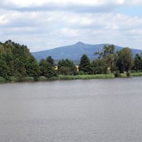
A cycling route starting in Dolní Podluží, Ústecký kraj, Czechia.
Overview
About this route
... in May 2013
Route highlights:
-
40 km E 442
-
Spindler Pass
-
Vrbatova Bouda
-
Double ascent Modre Sedlo: 40 km with 2250 m elevation gain
-
Prazska Bouda
-
Lvi Dul
-
Jelenka Bouda
-
3 km mountain run from Jelenka to Schneekoppe
- -:--
- Duration
- 380.4 km
- Distance
- 6,318 m
- Ascent
- 5,461 m
- Descent
- ---
- Avg. speed
- ---
- Max. altitude
Route quality
Waytypes & surfaces along the route
Waytypes
Track
102.7 km
(27 %)
Road
72.3 km
(19 %)
Surfaces
Paved
300.5 km
(79 %)
Unpaved
11.4 km
(3 %)
Asphalt
273.9 km
(72 %)
Paved (undefined)
26.6 km
(7 %)
Continue with Bikemap
Use, edit, or download this cycling route
You would like to ride JELENKA 10000 or customize it for your own trip? Here is what you can do with this Bikemap route:
Free features
- Save this route as favorite or in collections
- Copy & plan your own version of this route
- Split it into stages to create a multi-day tour
- Sync your route with Garmin or Wahoo
Premium features
Free trial for 3 days, or one-time payment. More about Bikemap Premium.
- Navigate this route on iOS & Android
- Export a GPX / KML file of this route
- Create your custom printout (try it for free)
- Download this route for offline navigation
Discover more Premium features.
Get Bikemap PremiumFrom our community
Other popular routes starting in Dolní Podluží
Okolo Malého Stožce- Distance
- 20.8 km
- Ascent
- 481 m
- Descent
- 484 m
- Location
- Dolní Podluží, Ústecký kraj, Czechia
SPOJBODY 2019- Distance
- 31.2 km
- Ascent
- 585 m
- Descent
- 585 m
- Location
- Dolní Podluží, Ústecký kraj, Czechia
Okolo Horní Světlé- Distance
- 21.2 km
- Ascent
- 427 m
- Descent
- 428 m
- Location
- Dolní Podluží, Ústecký kraj, Czechia
louzecky 1- Distance
- 21.9 km
- Ascent
- 1,175 m
- Descent
- 1,168 m
- Location
- Dolní Podluží, Ústecký kraj, Czechia
JELENKA 10000- Distance
- 380.4 km
- Ascent
- 6,318 m
- Descent
- 5,461 m
- Location
- Dolní Podluží, Ústecký kraj, Czechia
Jedlová, Luž, Růžová a DC- Distance
- 74 km
- Ascent
- 940 m
- Descent
- 1,342 m
- Location
- Dolní Podluží, Ústecký kraj, Czechia
Recording from 17:33 25. Červen- Distance
- 25 km
- Ascent
- 570 m
- Descent
- 567 m
- Location
- Dolní Podluží, Ústecký kraj, Czechia
Jedlova-Varnsdorf-Rumburk-Kyjov-Tokan-Vysoka Lipa-Hrensko-Decin- Distance
- 81.2 km
- Ascent
- 545 m
- Descent
- 875 m
- Location
- Dolní Podluží, Ústecký kraj, Czechia
Open it in the app


