

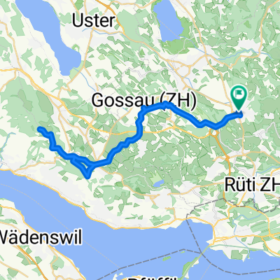
Hinwil - Oberdürnten - Wald - Diemberg - Jona - Dürnten
A cycling route starting in Hinwil, Canton of Zurich, Switzerland.
Overview
About this route
Asphalt and forest trails. Root path to Diemberg towards Jona.
- -:--
- Duration
- 36.2 km
- Distance
- 529 m
- Ascent
- 531 m
- Descent
- ---
- Avg. speed
- ---
- Max. altitude
Route quality
Waytypes & surfaces along the route
Waytypes
Road
11.2 km
(31 %)
Quiet road
10.1 km
(28 %)
Surfaces
Paved
22.1 km
(61 %)
Unpaved
8.3 km
(23 %)
Asphalt
20.6 km
(57 %)
Gravel
2.5 km
(7 %)
Continue with Bikemap
Use, edit, or download this cycling route
You would like to ride Hinwil - Oberdürnten - Wald - Diemberg - Jona - Dürnten or customize it for your own trip? Here is what you can do with this Bikemap route:
Free features
- Save this route as favorite or in collections
- Copy & plan your own version of this route
- Sync your route with Garmin or Wahoo
Premium features
Free trial for 3 days, or one-time payment. More about Bikemap Premium.
- Navigate this route on iOS & Android
- Export a GPX / KML file of this route
- Create your custom printout (try it for free)
- Download this route for offline navigation
Discover more Premium features.
Get Bikemap PremiumFrom our community
Other popular routes starting in Hinwil
 Hinwil - Oberdürnten - Wald - Diemberg - Jona - Dürnten
- Distance
- 36.2 km
- Ascent
- 529 m
- Descent
- 531 m
- Location
- Hinwil, Canton of Zurich, Switzerland
 Bachtelturm
- Distance
- 13.5 km
- Ascent
- 607 m
- Descent
- 607 m
- Location
- Hinwil, Canton of Zurich, Switzerland
 Pfannestiel
- Distance
- 37.7 km
- Ascent
- 527 m
- Descent
- 526 m
- Location
- Hinwil, Canton of Zurich, Switzerland
 OO_Hinwil_Bachtel_Päffikon_Wetzikon_Hinwil
- Distance
- 35.2 km
- Ascent
- 691 m
- Descent
- 691 m
- Location
- Hinwil, Canton of Zurich, Switzerland
 Ghöch - Schaufelbergeregg
- Distance
- 21.3 km
- Ascent
- 557 m
- Descent
- 557 m
- Location
- Hinwil, Canton of Zurich, Switzerland
 Bachtelranch
- Distance
- 10.9 km
- Ascent
- 376 m
- Descent
- 376 m
- Location
- Hinwil, Canton of Zurich, Switzerland
 CH: Rundkurs Zürisee
- Distance
- 58.6 km
- Ascent
- 289 m
- Descent
- 387 m
- Location
- Hinwil, Canton of Zurich, Switzerland
 grosse Winterthur-Umrundung
- Distance
- 125.9 km
- Ascent
- 895 m
- Descent
- 895 m
- Location
- Hinwil, Canton of Zurich, Switzerland
Open it in the app