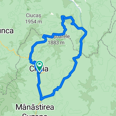
Cheia pod-Muntele Rosu
A cycling route starting in Slon, Prahova, Romania.
Overview
About this route
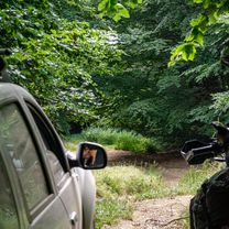
<div id="description"> <div id="description_short_full"> Catarare de categoria 1, f grea pt bicicleta. Catararea incepe din cheia de la pod, imediat ce se iese din DN. La inceput este o urcare usoara, abia dupa 1,5 km incepe sa se urce serios. Cateva serpentine si dupa se iese din nou in DN si incepe adevarata catarare cu panta medie 9 %. Pantele depasesc 20 % pe multe portiuni si in mare parte este padure. Abia cand se ajunge sus pe platou peisajul este cu adevarat superb.
Panta medie 8 %
Panta maxima 25 % <div class="dummy">.</div> </div> </div>
- -:--
- Duration
- 6.2 km
- Distance
- 572 m
- Ascent
- 76 m
- Descent
- ---
- Avg. speed
- ---
- Avg. speed
Route quality
Waytypes & surfaces along the route
Waytypes
Quiet road
3 km
(48 %)
Road
1.4 km
(23 %)
Surfaces
Paved
5.3 km
(85 %)
Unpaved
0.7 km
(11 %)
Asphalt
5.3 km
(85 %)
Ground
0.7 km
(11 %)
Undefined
0.2 km
(4 %)
Continue with Bikemap
Use, edit, or download this cycling route
You would like to ride Cheia pod-Muntele Rosu or customize it for your own trip? Here is what you can do with this Bikemap route:
Free features
- Save this route as favorite or in collections
- Copy & plan your own version of this route
- Sync your route with Garmin or Wahoo
Premium features
Free trial for 3 days, or one-time payment. More about Bikemap Premium.
- Navigate this route on iOS & Android
- Export a GPX / KML file of this route
- Create your custom printout (try it for free)
- Download this route for offline navigation
Discover more Premium features.
Get Bikemap PremiumFrom our community
Other popular routes starting in Slon
- Pe Valea Stanii la Lacul Volturilor
- Distance
- 26.9 km
- Ascent
- 995 m
- Descent
- 359 m
- Location
- Slon, Prahova, Romania
- Marele Ocol al Ciucasului: Cheia - Cab. Babarunca - Saua si Poiana tesei - P. Dalghiului - Crivina - Poiana Stanii - Cheia
- Distance
- 73.6 km
- Ascent
- 1,397 m
- Descent
- 1,397 m
- Location
- Slon, Prahova, Romania
- 1 munte - tura medie Cheia MTB Challenge 2020
- Distance
- 43.3 km
- Ascent
- 1,021 m
- Descent
- 1,023 m
- Location
- Slon, Prahova, Romania
- Cheia - Poiana Stanii - Pasul Boncuta
- Distance
- 32.8 km
- Ascent
- 594 m
- Descent
- 595 m
- Location
- Slon, Prahova, Romania
- Slon-LaculVulturilor Circuit
- Distance
- 66.6 km
- Ascent
- 1,440 m
- Descent
- 1,440 m
- Location
- Slon, Prahova, Romania
- Propunere Ciucas
- Distance
- 48.1 km
- Ascent
- 1,164 m
- Descent
- 1,167 m
- Location
- Slon, Prahova, Romania
- Circuit in Siriu Mountains
- Distance
- 46.3 km
- Ascent
- 1,109 m
- Descent
- 1,116 m
- Location
- Slon, Prahova, Romania
- Manastirea Cheia-Muntii Tataru
- Distance
- 59.1 km
- Ascent
- 1,193 m
- Descent
- 1,193 m
- Location
- Slon, Prahova, Romania