

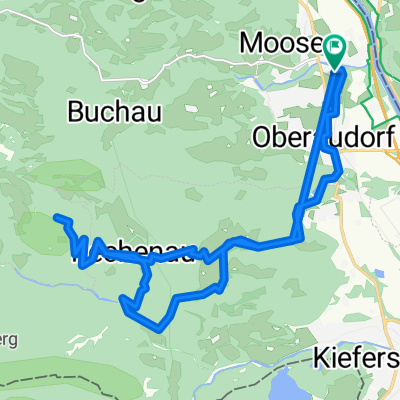
Priener Hütte
A cycling route starting in Oberaudorf, Bavaria, Germany.
Overview
About this route
From Sachrang, there is a forest road leading to the Priener Hütte, then a beautiful easy 300m trail descent (1-2) follows. The return to Sachrang takes the route over a small asphalt road.
- -:--
- Duration
- 24.7 km
- Distance
- 868 m
- Ascent
- 868 m
- Descent
- ---
- Avg. speed
- ---
- Max. altitude

Route highlights
Points of interest along the route
Point of interest after 8.5 km
Point of interest after 9 km
Geigelstein Gipfel mitnehmen, müsste nach Gelände und Sattelitenbild über die Alm auch schön abfahrbar sein.
Continue with Bikemap
Use, edit, or download this cycling route
You would like to ride Priener Hütte or customize it for your own trip? Here is what you can do with this Bikemap route:
Free features
- Save this route as favorite or in collections
- Copy & plan your own version of this route
- Sync your route with Garmin or Wahoo
Premium features
Free trial for 3 days, or one-time payment. More about Bikemap Premium.
- Navigate this route on iOS & Android
- Export a GPX / KML file of this route
- Create your custom printout (try it for free)
- Download this route for offline navigation
Discover more Premium features.
Get Bikemap PremiumFrom our community
Other popular routes starting in Oberaudorf
 Rennradrunde über Sudelfeld
- Distance
- 54.2 km
- Ascent
- 915 m
- Descent
- 915 m
- Location
- Oberaudorf, Bavaria, Germany
 MTB Kids & Family Tatzelwurm
- Distance
- 30.9 km
- Ascent
- 1,065 m
- Descent
- 1,046 m
- Location
- Oberaudorf, Bavaria, Germany
 Erlerberg Trockental
- Distance
- 37.5 km
- Ascent
- 1,186 m
- Descent
- 1,186 m
- Location
- Oberaudorf, Bavaria, Germany
 Erlerbergrunde
- Distance
- 23.4 km
- Ascent
- 740 m
- Descent
- 740 m
- Location
- Oberaudorf, Bavaria, Germany
 Brünnstein bis geht nimmer 🤣
- Distance
- 22.7 km
- Ascent
- 734 m
- Descent
- 719 m
- Location
- Oberaudorf, Bavaria, Germany
 Riesenkopf Umrundung
- Distance
- 32.4 km
- Ascent
- 852 m
- Descent
- 852 m
- Location
- Oberaudorf, Bavaria, Germany
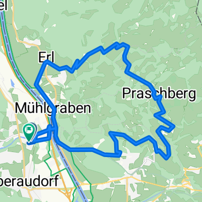 Praschbergrunde
- Distance
- 20.1 km
- Ascent
- 672 m
- Descent
- 669 m
- Location
- Oberaudorf, Bavaria, Germany
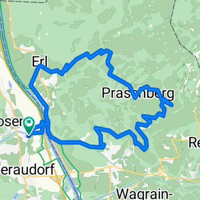 Niederndorfer über Praschberg retour
- Distance
- 22.5 km
- Ascent
- 723 m
- Descent
- 726 m
- Location
- Oberaudorf, Bavaria, Germany
Open it in the app