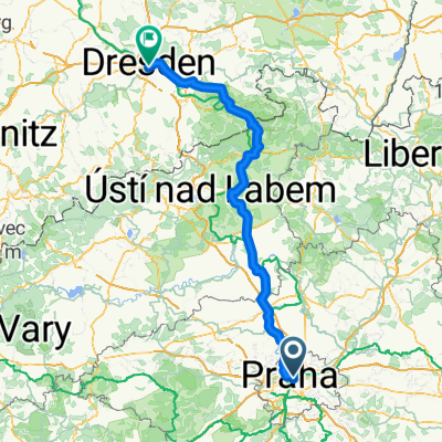
Cyklojízda z Palmovky 13. 12. 2012
A cycling route starting in Karlín, Hlavní město Praha, Czechia.
Overview
About this route
- -:--
- Duration
- 21.8 km
- Distance
- 220 m
- Ascent
- 123 m
- Descent
- ---
- Avg. speed
- ---
- Avg. speed
Route quality
Waytypes & surfaces along the route
Waytypes
Road
6.1 km
(28 %)
Busy road
4.7 km
(22 %)
Surfaces
Paved
19.3 km
(89 %)
Unpaved
1.1 km
(5 %)
Asphalt
18.6 km
(85 %)
Gravel
0.6 km
(3 %)
Route highlights
Points of interest along the route
Point of interest after 4.2 km
Start z Palmovky
Point of interest after 13.1 km
Ďáblická hvězdárna
Point of interest after 16.1 km
Chaberský menhir
Point of interest after 18.2 km
U Navrátilů
Continue with Bikemap
Use, edit, or download this cycling route
You would like to ride Cyklojízda z Palmovky 13. 12. 2012 or customize it for your own trip? Here is what you can do with this Bikemap route:
Free features
- Save this route as favorite or in collections
- Copy & plan your own version of this route
- Sync your route with Garmin or Wahoo
Premium features
Free trial for 3 days, or one-time payment. More about Bikemap Premium.
- Navigate this route on iOS & Android
- Export a GPX / KML file of this route
- Create your custom printout (try it for free)
- Download this route for offline navigation
Discover more Premium features.
Get Bikemap PremiumFrom our community
Other popular routes starting in Karlín
- Prag Troja to Melnik
- Distance
- 53 km
- Ascent
- 299 m
- Descent
- 315 m
- Location
- Karlín, Hlavní město Praha, Czechia
- Stromovka - Únětice okruhem přes Roztoky a Horoměřice
- Distance
- 28.7 km
- Ascent
- 244 m
- Descent
- 246 m
- Location
- Karlín, Hlavní město Praha, Czechia
- Švýcarské dny - ekolo.cz 18.4.
- Distance
- 12.3 km
- Ascent
- 102 m
- Descent
- 103 m
- Location
- Karlín, Hlavní město Praha, Czechia
- Round Trip Karlin through Stromovka
- Distance
- 20.7 km
- Ascent
- 98 m
- Descent
- 98 m
- Location
- Karlín, Hlavní město Praha, Czechia
- Točná, Radotín, Prokopské údolí
- Distance
- 53.7 km
- Ascent
- 466 m
- Descent
- 466 m
- Location
- Karlín, Hlavní město Praha, Czechia
- Moravian UNESCO
- Distance
- 443.7 km
- Ascent
- 749 m
- Descent
- 803 m
- Location
- Karlín, Hlavní město Praha, Czechia
- Etapa 048C (Praga - Písek)
- Distance
- 154.6 km
- Ascent
- 3,067 m
- Descent
- 2,892 m
- Location
- Karlín, Hlavní město Praha, Czechia
- Vrsovice - Hostivar - Pruhonice - Modranska rokle - Branik - Vrsovice
- Distance
- 40.1 km
- Ascent
- 181 m
- Descent
- 181 m
- Location
- Karlín, Hlavní město Praha, Czechia
Open it in the app