

KRAJEM VILÉMA TELLA A JEZER ŠVÝCARSKA NA KOLE
A cycling route starting in Zürich (Kreis 1), Canton of Zurich, Switzerland.
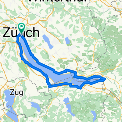
Overview
About this route
Cycling like sent from heaven – valleys among lakes with crystal-clear water and a mild climate, with breathtaking panoramic views of the mountain giants of the Alpine massif and charming mountain meadows and towns. In the wild landscape of the mysterious legends of William Tell and the steepest cog railways in the world, we can enjoy the true atmosphere of Switzerland.
- -:--
- Duration
- 337.2 km
- Distance
- 2,857 m
- Ascent
- 2,481 m
- Descent
- ---
- Avg. speed
- ---
- Max. altitude

Route quality
Waytypes & surfaces along the route
Waytypes
Quiet road
57.3 km
(17 %)
Track
33.7 km
(10 %)
Surfaces
Paved
225.9 km
(67 %)
Unpaved
30.3 km
(9 %)
Asphalt
199 km
(59 %)
Paved (undefined)
27 km
(8 %)
Route highlights
Points of interest along the route
Point of interest after 0.1 km
Curych
Point of interest after 11.3 km
Zurichsee
Point of interest after 32 km
Rapperswil
Point of interest after 36 km
Pfaffikon
Point of interest after 44.6 km
Sihlsee
Point of interest after 47.2 km
Einsiedeln
Point of interest after 65.3 km
Agerisee
Point of interest after 76.7 km
Zug
Point of interest after 77.8 km
Zugersee
Point of interest after 97.3 km
Lauerzersee
Point of interest after 102.2 km
Schwyz
Point of interest after 107.4 km
Brunnen
Point of interest after 108.1 km
Vierwaldstattersee
Point of interest after 151 km
Horw
Point of interest after 154.2 km
Luzern
Point of interest after 167.1 km
Pilatus
Point of interest after 182.2 km
Alpnachersee
Point of interest after 189.6 km
Sarnen
Point of interest after 190.4 km
Sarnensee
Point of interest after 212.6 km
Lungerersee
Point of interest after 220 km
Brunnigpass
Point of interest after 243.4 km
Meiringen
Point of interest after 256.9 km
Brienzersee
Point of interest after 301.1 km
Thun
Point of interest after 336.7 km
Staubbachfall
Point of interest after 337 km
Lauterbrunnen
Continue with Bikemap
Use, edit, or download this cycling route
You would like to ride KRAJEM VILÉMA TELLA A JEZER ŠVÝCARSKA NA KOLE or customize it for your own trip? Here is what you can do with this Bikemap route:
Free features
- Save this route as favorite or in collections
- Copy & plan your own version of this route
- Split it into stages to create a multi-day tour
- Sync your route with Garmin or Wahoo
Premium features
Free trial for 3 days, or one-time payment. More about Bikemap Premium.
- Navigate this route on iOS & Android
- Export a GPX / KML file of this route
- Create your custom printout (try it for free)
- Download this route for offline navigation
Discover more Premium features.
Get Bikemap PremiumFrom our community
Other popular routes starting in Zürich (Kreis 1)
 Day 1 - Zug
- Distance
- 69.9 km
- Ascent
- 870 m
- Descent
- 863 m
- Location
- Zürich (Kreis 1), Canton of Zurich, Switzerland
 Zürich-Lachen-Wägitalersee-Sattelegg-Einsiedeln-Richtersil
- Distance
- 96.9 km
- Ascent
- 1,766 m
- Descent
- 1,341 m
- Location
- Zürich (Kreis 1), Canton of Zurich, Switzerland
 3SeenTour
- Distance
- 179.2 km
- Ascent
- 930 m
- Descent
- 930 m
- Location
- Zürich (Kreis 1), Canton of Zurich, Switzerland
 Bellevue - Albis - Buchenegg - Bellevue
- Distance
- 33.8 km
- Ascent
- 643 m
- Descent
- 615 m
- Location
- Zürich (Kreis 1), Canton of Zurich, Switzerland
 Zürich Sattelegg Ibergeregg Arth Zug Aeugst Zürich
- Distance
- 149 km
- Ascent
- 1,669 m
- Descent
- 1,661 m
- Location
- Zürich (Kreis 1), Canton of Zurich, Switzerland
 Zeppelin_bici_archibike_Basilea_Zurigo_Lucerna_2015
- Distance
- 384.1 km
- Ascent
- 1,324 m
- Descent
- 1,294 m
- Location
- Zürich (Kreis 1), Canton of Zurich, Switzerland
 Schweizergrenze 1:5_Entwurf_2
- Distance
- 303.4 km
- Ascent
- 2,698 m
- Descent
- 2,697 m
- Location
- Zürich (Kreis 1), Canton of Zurich, Switzerland
 Rathausbrücke, Zurigo a Rathausbrücke, Zurigo
- Distance
- 109.1 km
- Ascent
- 1,413 m
- Descent
- 1,415 m
- Location
- Zürich (Kreis 1), Canton of Zurich, Switzerland
Open it in the app