

The Fog
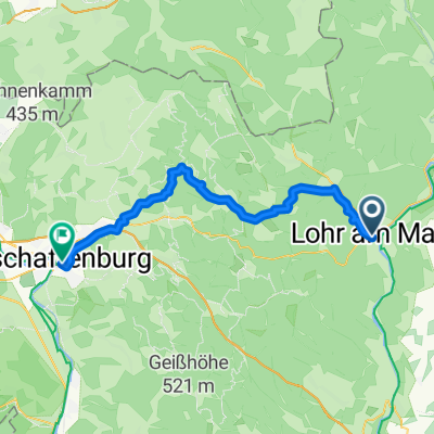
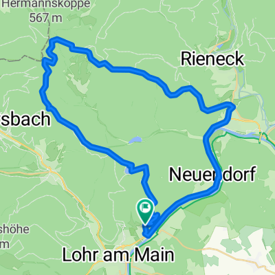
A cycling route starting in Lohr a. Main, Bavaria, Germany.
Overview
About this route
Sackenbach, Oberbecken, <span class="st">Katharinenbild, </span>über Hessenweg zur Bayrischen Schanz, über Birkenhainer nach Langenprozelten, am Main auf Radweg zurück nach Sackenbach
- -:--
- Duration
- 41 km
- Distance
- 683 m
- Ascent
- 683 m
- Descent
- ---
- Avg. speed
- ---
- Max. altitude
Route quality
Waytypes & surfaces along the route
Waytypes
Track
27.9 km
(68 %)
Cycleway
7.4 km
(18 %)
Surfaces
Paved
9 km
(22 %)
Unpaved
29.1 km
(71 %)
Gravel
18.5 km
(45 %)
Ground
10.3 km
(25 %)
Continue with Bikemap
Use, edit, or download this cycling route
You would like to ride The Fog or customize it for your own trip? Here is what you can do with this Bikemap route:
Free features
- Save this route as favorite or in collections
- Copy & plan your own version of this route
- Sync your route with Garmin or Wahoo
Premium features
Free trial for 3 days, or one-time payment. More about Bikemap Premium.
- Navigate this route on iOS & Android
- Export a GPX / KML file of this route
- Create your custom printout (try it for free)
- Download this route for offline navigation
Discover more Premium features.
Get Bikemap PremiumFrom our community
Other popular routes starting in Lohr a. Main
 Lohr am Main - Aschaffenburg
- Distance
- 46.1 km
- Ascent
- 849 m
- Descent
- 880 m
- Location
- Lohr a. Main, Bavaria, Germany
 Ausfahrt durch Lohr am Main
- Distance
- 27.1 km
- Ascent
- 364 m
- Descent
- 367 m
- Location
- Lohr a. Main, Bavaria, Germany
 11 Sinner Nordrunde
- Distance
- 80.6 km
- Ascent
- 508 m
- Descent
- 508 m
- Location
- Lohr a. Main, Bavaria, Germany
 The Fog
- Distance
- 41 km
- Ascent
- 683 m
- Descent
- 683 m
- Location
- Lohr a. Main, Bavaria, Germany
 Bike Lodge nach Michaelspfad
- Distance
- 51.4 km
- Ascent
- 687 m
- Descent
- 477 m
- Location
- Lohr a. Main, Bavaria, Germany
 Mainradweg Lohr - Bürgstadt
- Distance
- 76.4 km
- Ascent
- 670 m
- Descent
- 699 m
- Location
- Lohr a. Main, Bavaria, Germany
 Von Lohr am Main bis Frammersbacher Forst
- Distance
- 60.5 km
- Ascent
- 1,048 m
- Descent
- 1,046 m
- Location
- Lohr a. Main, Bavaria, Germany
 Kupfermühle(Lohr)-Partenstein-HLohrTal
- Distance
- 51.2 km
- Ascent
- 477 m
- Descent
- 491 m
- Location
- Lohr a. Main, Bavaria, Germany
Open it in the app